Premium Badge Aus dem App Store herunterladen Hol dir Bikemap auf Google Play Turn-by-Turn-Navigation Offline Maps Bike Type Optimized Routing Premium Maps Individueller Fahrradcomputer Routen-Export Route Previews Sturzerkennung Premium Support

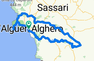
Radroute in Alghero, Sardinien, Italien

SGT-Randonnée 2015

0
Route in der Bikemap App öffnen

Route in der Bikemap App öffnen

Diese Route in Bikemap Web öffnen

Diese Route in Bikemap Web öffnen

195 km
Distanz
1608 m
Aufstieg
1608 m
Abstieg
-:-- h
Dauer
-- km/h
ø-Tempo
--- m
Max. Höhe

Ăśber diese Route

Second edition of SGT-Randonnée of sardiniagrandtour.com. In this event we’ll discover in one day the beauty of North West, along 200 epic km. We’ll start from Alghero’s ancient walls, facing immediately the “Scala Piccada”, a stunning climb overlooking the olive groves around this ancient cataln town. A long downhill will bring us till the banks of Temo lake, then we’ll cross the Logudoro countryside reaching the foothills of the vast Campeda plateau. The imposing fortified tower of Santu Antine nuraghe it’s our halway mark, we head towards Porto Conte bay, to climb the Capo Caccia limestone cliffs, just before getting back to Alghero.

Diese Fahrradroute ist ideal fĂĽr: Rennrad

Du fährst auf folgendem Untergrund: Asphaltiert

Passe diese Fahrradroute mit dem Bikemap-Routenplaner an.

Passe diese Route an!

Wusstest du schon? Du kannst diese Route als Vorlage in unserem Routenplaner verwenden, und sie ganz einfach nach deinen BedĂĽrfnissen anpassen. So planst du noch schneller deine perfekte Radtour.

In der App öffnen