

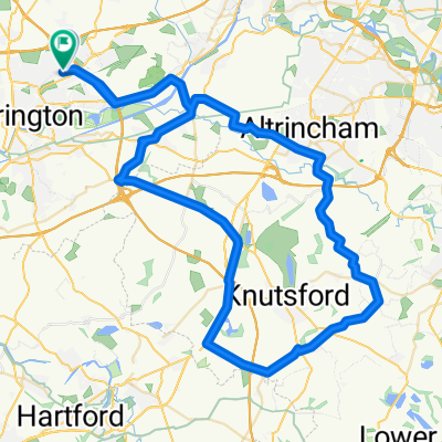
stretton - warburton loop
Eine Fahrradroute, die in Croft, England, United Kingdom beginnt.
Übersicht
Über diese Route
-
down fearnhead lane into padgate lane and then on to kingsway.
-
go over kingsway bridge and follow the road.. at the 2nd set of lights turn left and then immediatley right up the side of the canal (climb).
-
turn left at the top over the bridge and follow the road down turning right at the bottom.
-
at the lights turn right and then left at the next set (under a bridge) taking the first left (bridge lane)
-
turn right into broom ave which becomes lyons road.
-
at the end of the road, turn left into london road.
-
eventually turn right into hatton lane
-
as the road splits, turn left and go under the M6... turning right into pilmoss lane.
-
turn left into newton lane and then right into higher lane.
-
turn left into marsh lane (cross over tarporley road into heath lane)
*take ash house lane off to the left which becomes coghill lane - follow this and trun right into hough lane.
-
as hough lane goes off to the right - STOP on the road and go back into gogshall lane turning right into marbury road.
-
turn right into budworth lane - cross the a559 into high street and join westgate lane. bare left onto budworth road.
-
turn left into CANN lane and go under the M6... you are now in whitley lane.
-
turn left into rowey bank lane and then right into halliwells brow.
-
as you hit the a50 turn left and then right into W lane (high leigh). Follow this under the M56 and into high leigh road
-
at the a56 (higher lane) cross over into bullford lane)
-
go over the canal into mill lane
-
at the a6144 turn right into heatley and left on the b5159 (townfield lane)
-
follow this through the toll road.... and left on to manchester road..... then home...
- -:--
- Dauer
- 54,6 km
- Distanz
- 144 m
- Aufstieg
- 142 m
- Abstieg
- ---
- Ø-Tempo
- ---
- Ø-Tempo

Weiter mit Bikemap
Diese Radroute verwenden, bearbeiten oder herunterladen
Du möchtest stretton - warburton loop fahren oder sie für deine eigene Reise anpassen? Folgendes kannst du mit dieser Bikemap-Route machen:
Gratis Funktionen
- Speichere diese Route als Favorit oder in einer Sammlung
- Kopiere & plane deine eigene Version dieser Route
- Synchronisiere deine Route mit Garmin oder Wahoo
Premium-Funktionen
Kostenlose Testversion für 3 Tage oder einmalige Zahlung. Mehr über Bikemap Premium.
- Navigiere diese Route auf iOS & Android
- Exportiere eine GPX / KML-Datei dieser Route
- Erstelle deinen individuellen Ausdruck (Jetzt kostenlos ausprobieren)
- Lade diese Route für die Offline-Navigation herunter
Entdecke weitere Premium-Funktionen.
Bikemap Premium aktivierenVon unserer Community
Croft: Andere beliebte Routen, die hier beginnen
 stretton - warburton loop
- Distanz
- 54,6 km
- Aufstieg
- 144 m
- Abstieg
- 142 m
- Standort
- Croft, England, Vereinigtes Königreich
 tatton circular
- Distanz
- 55,5 km
- Aufstieg
- 135 m
- Abstieg
- 135 m
- Standort
- Croft, England, Vereinigtes Königreich
 delamere circular
- Distanz
- 78,9 km
- Aufstieg
- 353 m
- Abstieg
- 354 m
- Standort
- Croft, England, Vereinigtes Königreich
 appleton, stretton, daresbury 29.5mile
- Distanz
- 47,5 km
- Aufstieg
- 143 m
- Abstieg
- 143 m
- Standort
- Croft, England, Vereinigtes Königreich
 leigh 18 miler
- Distanz
- 29,4 km
- Aufstieg
- 65 m
- Abstieg
- 66 m
- Standort
- Croft, England, Vereinigtes Königreich
 Route from Moss Gate, Birchwood, Warrington
- Distanz
- 12,2 km
- Aufstieg
- 122 m
- Abstieg
- 89 m
- Standort
- Croft, England, Vereinigtes Königreich
 to dan's
- Distanz
- 6,7 km
- Aufstieg
- 8 m
- Abstieg
- 8 m
- Standort
- Croft, England, Vereinigtes Königreich
 knutsfors peeover route
- Distanz
- 69,8 km
- Aufstieg
- 146 m
- Abstieg
- 149 m
- Standort
- Croft, England, Vereinigtes Königreich
In der App öffnen