

tatton circular
Eine Fahrradroute, die in Croft, England, United Kingdom beginnt.
Übersicht
Über diese Route
-
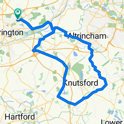
head to warby toll bridge. once over the bridge, follow the road to la bohmem. Turn left just after (MILL LANE)
-
this becomes BURFORD LANE
-
at the cross junction, go straight over into HIGH LEIGH road, this becomes WEST LANE.
-
go over the motorway and pick up the cycle route 70 to the left.
-
Follow the route and once on BROAD OAK lane nr mobberley leave the route to the right onto KNUTSFORD road to the right. this cecomed MOBERLEY road.
-
Turn right as the road joins brook street heading for the a50 (manchester road) follow this into mere and cross the A556 and carry on.....
-
before hitting the M56 turn RIGHT down MAG LANE.
-
Turn LEFT into CROUCHELY LANE and left onto CHURCH ROAD
-
follow through lymm and head home..
- -:--
- Dauer
- 55,5 km
- Distanz
- 135 m
- Aufstieg
- 135 m
- Abstieg
- ---
- Ø-Tempo
- ---
- Ø-Tempo

Weiter mit Bikemap
Diese Radroute verwenden, bearbeiten oder herunterladen
Du möchtest tatton circular fahren oder sie für deine eigene Reise anpassen? Folgendes kannst du mit dieser Bikemap-Route machen:
Gratis Funktionen
- Speichere diese Route als Favorit oder in einer Sammlung
- Kopiere & plane deine eigene Version dieser Route
- Synchronisiere deine Route mit Garmin oder Wahoo
Premium-Funktionen
Kostenlose Testversion für 3 Tage oder einmalige Zahlung. Mehr über Bikemap Premium.
- Navigiere diese Route auf iOS & Android
- Exportiere eine GPX / KML-Datei dieser Route
- Erstelle deinen individuellen Ausdruck (Jetzt kostenlos ausprobieren)
- Lade diese Route für die Offline-Navigation herunter
Entdecke weitere Premium-Funktionen.
Bikemap Premium aktivierenVon unserer Community
Croft: Andere beliebte Routen, die hier beginnen
 to dan's
- Distanz
- 6,7 km
- Aufstieg
- 8 m
- Abstieg
- 8 m
- Standort
- Croft, England, Vereinigtes Königreich
 stretton - warburton loop
- Distanz
- 54,6 km
- Aufstieg
- 144 m
- Abstieg
- 142 m
- Standort
- Croft, England, Vereinigtes Königreich
 tatton circular
- Distanz
- 55,5 km
- Aufstieg
- 135 m
- Abstieg
- 135 m
- Standort
- Croft, England, Vereinigtes Königreich
 delamere circular
- Distanz
- 78,9 km
- Aufstieg
- 353 m
- Abstieg
- 354 m
- Standort
- Croft, England, Vereinigtes Königreich
 leigh 18 miler
- Distanz
- 29,4 km
- Aufstieg
- 65 m
- Abstieg
- 66 m
- Standort
- Croft, England, Vereinigtes Königreich
 knutsfors peeover route
- Distanz
- 69,8 km
- Aufstieg
- 146 m
- Abstieg
- 149 m
- Standort
- Croft, England, Vereinigtes Königreich
 appleton, stretton, daresbury 29.5mile
- Distanz
- 47,5 km
- Aufstieg
- 143 m
- Abstieg
- 143 m
- Standort
- Croft, England, Vereinigtes Königreich
 Route from Moss Gate, Birchwood, Warrington
- Distanz
- 12,2 km
- Aufstieg
- 122 m
- Abstieg
- 89 m
- Standort
- Croft, England, Vereinigtes Königreich
In der App öffnen