For your gravel bike
Explore the world’s best gravel routes
From alpine fire roads to coastal forest trails—these are the top-rated gravel routes from the Bikemap community. Get inspired and start planning your next ride.
 Rund um die Osterseen
- Distance
- 39.2 km
- Ascent
- 381 m
- Descent
- 383 m
- Location
- Seeshaupt, Bavaria, Germany
 Wörthersee-Süduferstraße 55A, Klagenfurt am Wörthersee to Wörthersee-Süduferstraße 55A, Klagenfurt am Wörthersee
- Distance
- 45.1 km
- Ascent
- 306 m
- Descent
- 340 m
- Location
- Klagenfurt, Carinthia, Austria
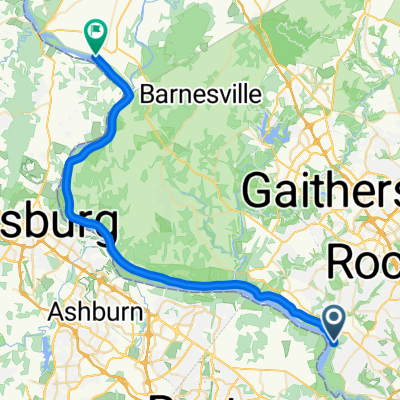 9-11 Trail: Potomac to Point of Rocks
- Distance
- 46.9 km
- Ascent
- 142 m
- Descent
- 131 m
- Location
- Potomac, Maryland, United States of America
 20 mi N Canton loop
- Distance
- 32.1 km
- Ascent
- 239 m
- Descent
- 238 m
- Location
- Canton, Ohio, United States of America
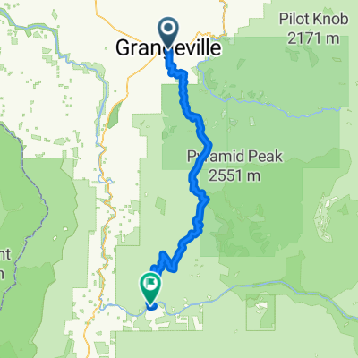 grangeville -> Riggins
- Distance
- 100.8 km
- Ascent
- 3,112 m
- Descent
- 3,585 m
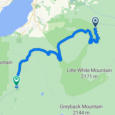 Route to Chute Lake Lodge
- Distance
- 36.3 km
- Ascent
- 909 m
- Descent
- 985 m
- Location
- Kelowna, British Columbia, Canada
 A CANESSA x RUTA 3 Y CORTI
- Distance
- 30.1 km
- Ascent
- 103 m
- Descent
- 44 m
- Location
- Bahía Blanca, Buenos Aires, Argentina
 Bogota- Laguna Pedro Palo
- Distance
- 108.9 km
- Ascent
- 1,860 m
- Descent
- 1,861 m
- Location
- Bogotá, Bogota D.C., Colombia
 Bottle Lake Forest, Christchurch
- Distance
- 34.3 km
- Ascent
- 77 m
- Descent
- 80 m
- Location
- Christchurch, Canterbury, New Zealand
 Half 8 Wired Wairarapa
- Distance
- 71.8 km
- Ascent
- 1,642 m
- Descent
- 1,636 m
- Location
- Waipawa, Wellington, New Zealand
 Bunyip to Pakenham via Gembrook 54 km
- Distance
- 53.5 km
- Ascent
- 778 m
- Descent
- 805 m
- Location
- Bunyip, Victoria, Australia
 Over The Range Ride ( + Willunga Bakery )
- Distance
- 40.2 km
- Ascent
- 515 m
- Descent
- 515 m
- Location
- Moana, South Australia, Australia
 宇老大滿貫
宇老大滿貫- Distance
- 115.5 km
- Ascent
- 1,867 m
- Descent
- 1,863 m
- Location
- Daxi, Taiwan, Taiwan
 TongHo Trail to YiLan - 桶後越嶺
- Distance
- 43.7 km
- Ascent
- 810 m
- Descent
- 988 m
 Ajmer to Jaipur
- Distance
- 138.6 km
- Ascent
- 263 m
- Descent
- 305 m
- Location
- Ajmer, Rajasthan, India
 Baba Harishchandra Marg 2021, Jaipur to Virat Nagar Road 519, Kishangarh
- Distance
- 110.1 km
- Ascent
- 150 m
- Descent
- 151 m
- Location
- Jaipur, Rajasthan, India
 talata volonondry
- Distance
- 61.1 km
- Ascent
- 1,201 m
- Descent
- 1,247 m
- Location
- Antananarivo, Analamanga Region, Madagascar
 Charles Street to R404
- Distance
- 42.1 km
- Ascent
- 491 m
- Descent
- 496 m
- Location
- George, Province of the Western Cape, Republic of South Africa
 Queensbridge Road 303 to Queensbridge Road 303
- Distance
- 30.1 km
- Ascent
- 48 m
- Descent
- 92 m
- Location
- Bethnal Green, England, United Kingdom
 Camberwell Purfleet Circular
- Distance
- 73 km
- Ascent
- 202 m
- Descent
- 203 m
- Location
- Camberwell, England, United Kingdom