For your gravel bike
Explore the world’s best gravel routes
From alpine fire roads to coastal forest trails—these are the top-rated gravel routes from the Bikemap community. Get inspired and start planning your next ride.
 Trogalmrunde - Neuseß - Mariapfarr - Weißpriach
- Distance
- 63.3 km
- Ascent
- 1,820 m
- Descent
- 1,818 m
- Location
- Mauterndorf, Salzburg, Austria
 München-Forst Kasten-Baierbrunn-Großhesselohe
- Distance
- 31.1 km
- Ascent
- 271 m
- Descent
- 273 m
- Location
- Baierbrunn, Bavaria, Germany
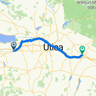 Solvay - Rome
- Distance
- 94.2 km
- Ascent
- 350 m
- Descent
- 311 m
- Location
- Canastota, New York, United States of America
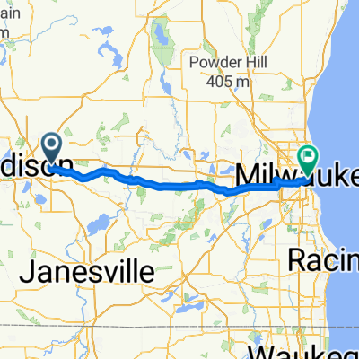 From Cottage Grove to Milwaukee
- Distance
- 120.9 km
- Ascent
- 501 m
- Descent
- 589 m
- Location
- Cottage Grove, Wisconsin, United States of America
 Beachside Dr, Parksville to Beachside Dr, Parksville
- Distance
- 30.2 km
- Ascent
- 279 m
- Descent
- 278 m
- Location
- Parksville, British Columbia, Canada
 Fay Road Northeast to Cedar Falls Road Southeast
- Distance
- 56.5 km
- Ascent
- 665 m
- Descent
- 496 m
- Location
- Lake Marcel-Stillwater, Washington, United States of America
 PRIMAR PLAZA, PEDRA DO INDIO, INDIANA
- Distance
- 56.2 km
- Ascent
- 682 m
- Descent
- 682 m
- Location
- Botucatu, São Paulo, Brazil
 050 - Cachoeira do Céu o Retorno II 35.67 km Odo 994.7 km
- Distance
- 35.7 km
- Ascent
- 312 m
- Descent
- 315 m
- Location
- Campo Grande, Mato Grosso do Sul, Brazil
 Queen Charlotte Track
- Distance
- 41.3 km
- Ascent
- 1,176 m
- Descent
- 1,176 m
- Location
- Picton, Marlborough, New Zealand
 Day10 Queenstown to Te Anau track
- Distance
- 116.9 km
- Ascent
- 747 m
- Descent
- 864 m
- Location
- Queenstown, Otago, New Zealand
 Yarra, Plenty, Ring and Merri
- Distance
- 72.1 km
- Ascent
- 257 m
- Descent
- 259 m
- Location
- Fairfield, Victoria, Australia
 Escooter river run
- Distance
- 31.7 km
- Ascent
- 170 m
- Descent
- 171 m
- Location
- Balmoral, Queensland, Australia
 Ocean Deep
- Distance
- 105.4 km
- Ascent
- 52 m
- Descent
- 49 m
- Location
- Changning, Shanghai Municipality, China
 계수동 산75-5, 시흥시 to 풍산동 554−4, 고양시
- Distance
- 38.9 km
- Ascent
- 230 m
- Descent
- 240 m
- Location
- Kwangmyŏng, Gyeonggi-do, Republic of Korea
 ride
ride- Distance
- 35.7 km
- Ascent
- 538 m
- Descent
- 537 m
- Location
- Patan, Central Region, Nepal
 Gurgaon to Indorie Qila
- Distance
- 122.4 km
- Ascent
- 278 m
- Descent
- 275 m
- Location
- Gurgaon, Haryana, India
 MW_Chiweta - Usisya Bay
- Distance
- 51.9 km
- Ascent
- 572 m
- Descent
- 354 m
- Location
- Livingstonia, Northern Region, Malawi
 Chibuluma to Chapula Circuit
- Distance
- 35.1 km
- Ascent
- 155 m
- Descent
- 154 m
- Location
- Kalulushi, Copperbelt, Zambia
 Marylebone to Epping Forrest
- Distance
- 62.3 km
- Ascent
- 250 m
- Descent
- 251 m
- Location
- West End of London, England, United Kingdom
 Route IBIKELONDON - Get To Know London - Check Out The View!
- Distance
- 30.7 km
- Ascent
- 242 m
- Descent
- 240 m
- Location
- West End of London, England, United Kingdom