For your mountain bike
Shred the world’s best mountain bike trails
From rooty forest loops to alpine descents—these are the highest-rated MTB routes shared by riders like you. Get ready to ride.
 Z Mauterndorf do údolí Lessachtal
- Distance
- 61.1 km
- Ascent
- 857 m
- Descent
- 851 m
- Location
- Mauterndorf, Salzburg, Austria
 17.06.09 Mörbisch-Sopron-Fertörakos-Mörbisch
- Distance
- 53.6 km
- Ascent
- 442 m
- Descent
- 439 m
- Location
- Mörbisch am See, Burgenland, Austria
 Montpelier to liberty mills to spicer mill and back
- Distance
- 36.6 km
- Ascent
- 639 m
- Descent
- 645 m
- Location
- Orange, Virginia, United States of America
 AHC NW 2 - White Rock to Oark
- Distance
- 62.2 km
- Ascent
- 1,217 m
- Descent
- 1,399 m
 Ross - Five Points - Lake Lagunitas - Eldridge Loop
- Distance
- 15.8 km
- Ascent
- 467 m
- Descent
- 464 m
- Location
- Ross, California, United States of America
 Recording from January 24, 10:51 AM
- Distance
- 14.9 km
- Ascent
- 465 m
- Descent
- 466 m
- Location
- Rancho Cucamonga, California, United States of America
 T6: CUNHA/SP - PARATY/RJ
- Distance
- 46.2 km
- Ascent
- 1,607 m
- Descent
- 2,554 m
- Location
- Cunha, São Paulo, Brazil
 T5: SÃO LUIZ DO PARAITINGA - CUNHA
- Distance
- 66 km
- Ascent
- 2,183 m
- Descent
- 2,008 m
 Otutira Drive 31, Marotiri to Otutira Drive 31, Marotiri
- Distance
- 33.9 km
- Ascent
- 607 m
- Descent
- 607 m
 geraldine fairlie
- Distance
- 62.9 km
- Ascent
- 902 m
- Descent
- 711 m
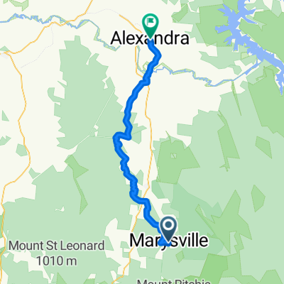
 Healesvil to Marysville
- Distance
- 40.5 km
- Ascent
- 1,377 m
- Descent
- 1,031 m
 Untitled route
- Distance
- 53.8 km
- Ascent
- 1,069 m
- Descent
- 1,274 m
 新店-直潭-廣興-烏來
- Distance
- 44.1 km
- Ascent
- 1,479 m
- Descent
- 1,439 m
- Location
- Banqiao District, Taipei, Taiwan
 20090405_沙溪林道
- Distance
- 13.9 km
- Ascent
- 743 m
- Descent
- 413 m
 Clock Tower - Debsi - Clock Tower
- Distance
- 17.6 km
- Ascent
- 437 m
- Descent
- 435 m
- Location
- Lungtenzampa, Thimphu Dzongkhag, Bhutan
 Mae Sariang-Hot Springs
- Distance
- 36.4 km
- Ascent
- 656 m
- Descent
- 658 m
- Location
- Ban Huai I Huak, Changwat Mae Hong Son, Thailand
 dada malala ambohibary
- Distance
- 50.6 km
- Ascent
- 938 m
- Descent
- 946 m
- Location
- Antananarivo, Analamanga Region, Madagascar
 De Unnamed Road à RN2, Antananarivo
- Distance
- 24.8 km
- Ascent
- 433 m
- Descent
- 509 m
- Location
- Antananarivo, Analamanga Region, Madagascar
 favourite 1
- Distance
- 12 km
- Ascent
- 3,612 m
- Descent
- 3,626 m
- Location
- Southall, England, United Kingdom
 MTB-Potters Bar Loop 2024
- Distance
- 56.5 km
- Ascent
- 415 m
- Descent
- 414 m
- Location
- Potters Bar, England, United Kingdom