For your mountain bike
Shred the world’s best mountain bike trails
From rooty forest loops to alpine descents—these are the highest-rated MTB routes shared by riders like you. Get ready to ride.
 Na Katarino mimo Golega Brda
- Distance
- 20.5 km
- Ascent
- 485 m
- Descent
- 463 m
- Location
- Medvode, Medvode, Slovenia
 Na Osolnik
- Distance
- 16.6 km
- Ascent
- 472 m
- Descent
- 442 m
- Location
- Medvode, Medvode, Slovenia
 199 Polly Drummond Hill Rd, Newark to 199 Polly Drummond Hill Rd, Newark
- Distance
- 17.1 km
- Ascent
- 415 m
- Descent
- 416 m
- Location
- Pike Creek, Delaware, United States
 Fairfield-Sheldon Hill Ride
- Distance
- 67.5 km
- Ascent
- 1,012 m
- Descent
- 1,012 m
- Location
- Saint Albans, Vermont, United States
 Exit 85 I-90 to Kachess Lake & return
- Distance
- 48.3 km
- Ascent
- 401 m
- Descent
- 324 m
 Rattlesnake Lake to Hyak with Matt; return
- Distance
- 69.6 km
- Ascent
- 658 m
- Descent
- 599 m
- Location
- Riverbend, Washington, United States
 QUIMIAG RIO BLANCO
- Distance
- 27.6 km
- Ascent
- 725 m
- Descent
- 460 m
- Location
- Guano, Provincia del Chimborazo, Ecuador
 CIRCUITO CAPILLA BUFFO (UNQUILLO)
- Distance
- 32.3 km
- Ascent
- 445 m
- Descent
- 40 m
- Location
- Córdoba, Cordoba Province, Argentina
 Stage 7
- Distance
- 68.8 km
- Ascent
- 549 m
- Descent
- 480 m
 Stage 10
- Distance
- 54.9 km
- Ascent
- 569 m
- Descent
- 563 m
 Millfield to Cessnock loop
- Distance
- 37.3 km
- Ascent
- 430 m
- Descent
- 430 m
- Location
- Cessnock, New South Wales, Australia
 Mooloolaba - Rosemount - Tower Mtn - Ilkley Loop
- Distance
- 56.6 km
- Ascent
- 432 m
- Descent
- 432 m
- Location
- Mooloolabah, Queensland, Australia
 South Tokushima Coastal Route
- Distance
- 68.9 km
- Ascent
- 1,885 m
- Descent
- 1,869 m
 埔里武界奧萬大霧社埔里繞圈
- Distance
- 69.7 km
- Ascent
- 1,500 m
- Descent
- 1,500 m
- Location
- Puli, Taiwan, Taiwan
 Morning ride ( 4 . Jan . 2024)
- Distance
- 33.6 km
- Ascent
- 417 m
- Descent
- 356 m
- Location
- Yangon, Yangon, Myanmar
 Lovely Hill 2 - Pokhara
- Distance
- 13.6 km
- Ascent
- 427 m
- Descent
- 421 m
- Location
- Pokhara, Western Region, Nepal
 Day 1
Day 1- Distance
- 63.1 km
- Ascent
- 897 m
- Descent
- 979 m
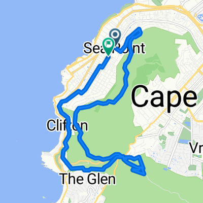 Signal Hill Climb Lion Cable Glen
- Distance
- 15.1 km
- Ascent
- 735 m
- Descent
- 735 m
- Location
- Cape Town, Western Cape, Republic of South Africa
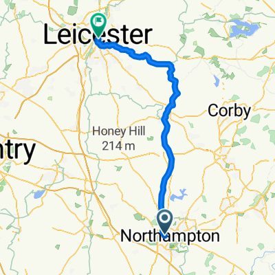 Northampton - Leicester
- Distance
- 64.6 km
- Ascent
- 478 m
- Descent
- 468 m
- Location
- Northampton, England, United Kingdom
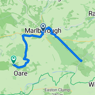 Route in Marlborough
- Distance
- 27.7 km
- Ascent
- 424 m
- Descent
- 320 m
- Location
- Marlborough, England, United Kingdom