For your road bike
Ride the world's best road cycling routes
From legendary alpine passes to rolling coastal highways—these are the top-rated road bike routes from the Bikemap community. Get inspired and ride your perfect line.
 Weltkulturerbe Route von Gloggnitz Bahnhof auf den Semmering
- Distance
- 36.2 km
- Ascent
- 1,022 m
- Descent
- 1,021 m
- Location
- Gloggnitz, Lower Austria, Austria
 Zur Steirer Hütt'n Am Gutenmann
- Distance
- 31.6 km
- Ascent
- 840 m
- Descent
- 839 m
- Location
- Ternitz, Lower Austria, Austria
 Bramalea to Malton Via Chinguacousy Trail, Heart Lake and Etobicoke Creek
- Distance
- 47 km
- Ascent
- 197 m
- Descent
- 217 m
- Location
- Brampton, Ontario, Canada
 Austin - Circle to MT Supermarket and Walnut Creek
- Distance
- 49.2 km
- Ascent
- 414 m
- Descent
- 413 m
- Location
- Rollingwood, Texas, United States
 Seattle to Marysville
- Distance
- 76.1 km
- Ascent
- 650 m
- Descent
- 688 m
- Location
- Seattle, Washington, United States
 Mayne Island Tour
- Distance
- 52.1 km
- Ascent
- 224 m
- Descent
- 206 m
 cipreses
- Distance
- 107.2 km
- Ascent
- 1,239 m
- Descent
- 1,261 m
- Location
- Graneros, Región del Libertador General Bernardo O’Higgins, Chile
 corinto, piuchena
- Distance
- 31 km
- Ascent
- 301 m
- Descent
- 371 m
 Pureora Forest Park to Ongarue
- Distance
- 72.3 km
- Ascent
- 1,083 m
- Descent
- 1,384 m
 Wellington Around the Bays
- Distance
- 41.3 km
- Ascent
- 949 m
- Descent
- 949 m
- Location
- Kelburn, Wellington Region, New Zealand
 Aussie World From Mooloolaba
- Distance
- 31.4 km
- Ascent
- 177 m
- Descent
- 177 m
- Location
- Mooloolabah, Queensland, Australia
 Parramatta Loop-Wentworth Point-Sydney Olympic Park-Harris Park Loop
- Distance
- 30.5 km
- Ascent
- 204 m
- Descent
- 203 m
- Location
- City of Parramatta, New South Wales, Australia
 Route nach Tokio, Kanto
- Distance
- 136.6 km
- Ascent
- 263 m
- Descent
- 265 m
- Location
- Urayasu, Tokyo, Japan
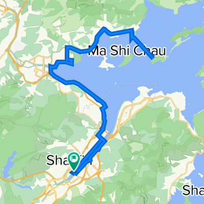 Lengthy ride through Sha Tin to Tai Po
- Distance
- 47.6 km
- Ascent
- 87 m
- Descent
- 85 m
- Location
- Shatin, Sha Tin, Hong Kong
 Restful route
- Distance
- 30.2 km
- Ascent
- 597 m
- Descent
- 572 m
- Location
- Valvettithurai, Northern Province, Sri Lanka
 Steady ride
- Distance
- 36.1 km
- Ascent
- 459 m
- Descent
- 358 m
- Location
- Valvettithurai, Northern Province, Sri Lanka
 Landrani to Raubenheimer dam
- Distance
- 34.6 km
- Ascent
- 448 m
- Descent
- 606 m
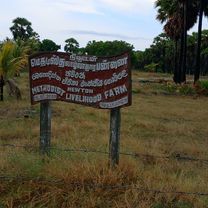
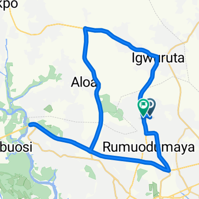 Rukpokwu to Elipokwoudu Road
- Distance
- 54.2 km
- Ascent
- 76 m
- Descent
- 80 m
- Location
- Rumuodomaya, Rivers State, Nigeria
 Wandle and Thames Path 4
- Distance
- 52.5 km
- Ascent
- 153 m
- Descent
- 153 m
- Location
- Chelsea, England, United Kingdom
 NCTC - Aldeburgh Club Ride - Newmarket to Aldeburgh
- Distance
- 108.3 km
- Ascent
- 289 m
- Descent
- 315 m
- Location
- Newmarket, England, United Kingdom