
Cycling in Lindford
Discover a map of 32 cycling routes and bike trails near Lindford, created by our community.
Region portrait
Get to know Lindford
Find the right bike route for you through Lindford, where we've got 32 cycle routes to explore.
864 km
Tracked distance
32
Cycle routes
Community
Most active users in Lindford


From our community
The best bike routes in and around Lindford

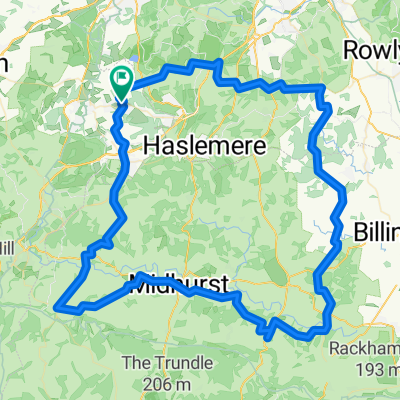
Dockenfield to Graffham
Cycling route in Lindford, England, United Kingdom
- 59.4 km
- Distance
- 367 m
- Ascent
- 405 m
- Descent

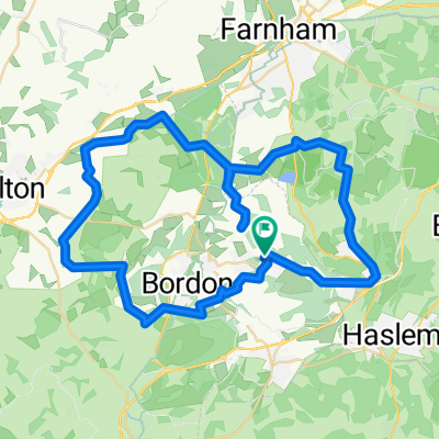
The Hanger, Bordon to Eden Lodge, Tilford Road, Farnham
Cycling route in Lindford, England, United Kingdom
- 9.5 km
- Distance
- 85 m
- Ascent
- 96 m
- Descent

Short bike tour from Bordon to Farnham
Cycling route in Lindford, England, United Kingdom
Walk to blue bell
- 5.9 km
- Distance
- 79 m
- Ascent
- 49 m
- Descent

Discover more routes
 102km (Plus South Harting Option)
- Distance
- 102.3 km
- Ascent
- 690 m
- Descent
- 690 m
- Location
- Lindford, England, United Kingdom
 Ciclopromenada nocturna de Anglia
- Distance
- 29 km
- Ascent
- 233 m
- Descent
- 235 m
- Location
- Lindford, England, United Kingdom
 Blue Bell
- Distance
- 5.3 km
- Ascent
- 80 m
- Descent
- 42 m
- Location
- Lindford, England, United Kingdom
 36km loop via Elstead
- Distance
- 36 km
- Ascent
- 290 m
- Descent
- 290 m
- Location
- Lindford, England, United Kingdom
 Windsor Road 15, Lindford to Sands Road 6, The Sands
- Distance
- 16.4 km
- Ascent
- 167 m
- Descent
- 151 m
- Location
- Lindford, England, United Kingdom
 25km to reach the foot of South Harting
- Distance
- 50.9 km
- Ascent
- 450 m
- Descent
- 450 m
- Location
- Lindford, England, United Kingdom
 57km loop
- Distance
- 56.9 km
- Ascent
- 1,070 m
- Descent
- 1,070 m
- Location
- Lindford, England, United Kingdom
 Deoli, Beech Hill Road, Bordon to Heatherbank, Beech Hill Road, Bordon
- Distance
- 0.3 km
- Ascent
- 18 m
- Descent
- 19 m
- Location
- Lindford, England, United Kingdom