
Cycling in Thanyaburi
Discover a map of 27 cycling routes and bike trails near Thanyaburi, created by our community.
Region portrait
Get to know Thanyaburi
Find the right bike route for you through Thanyaburi, where we've got 27 cycle routes to explore.
1,623 km
Tracked distance
27
Cycle routes
123,382
Population
Community
Most active users in Thanyaburi


From our community
The best bike routes in and around Thanyaburi


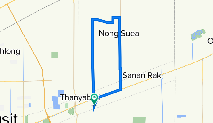
J3 - Vendredi 17/01/2014 - Thanya Buri - Ayutthaya
Cycling route in Thanyaburi, Pathum Thani, Thailand
J3 - Vendredi 17/01/2014 - Thanya Buri - Ayutthaya - 55 kms
13, 77 km/h - plat
- 53.9 km
- Distance
- 8 m
- Ascent
- 6 m
- Descent

grok e-dok
Cycling route in Thanyaburi, Pathum Thani, Thailand
<span style="color: #909191; font-family: 'lucida grande', arial, verdana, sans-serif; font-size: 12px;">rode up to grok e-dok again, went up khlong 7, the road is pretty bad. messed up my schedule (almost double the planned time). the road up into grok e-dok itself got messed up during the rainy season (stream side edges got washed out) & slowed me down to a crawl. got 2 flats in the dark 9km from home & called it quits (hopped a taxi).</span>
- 173.3 km
- Distance
- 200 m
- Ascent
- 200 m
- Descent


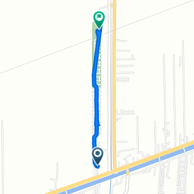
Recovered Route
Cycling route in Thanyaburi, Pathum Thani, Thailand
- 42.2 km
- Distance
- 0 m
- Ascent
- 3 m
- Descent
Discover more routes
 Jour 3 - Thanya Buri - Ayutthaya - 58 Kms
- Distance
- 55.5 km
- Ascent
- 24 m
- Descent
- 20 m
- Location
- Thanyaburi, Pathum Thani, Thailand
 two day
- Distance
- 2.6 km
- Ascent
- 4 m
- Descent
- 4 m
- Location
- Thanyaburi, Pathum Thani, Thailand
 ตำบล บึงบอน to ประเทศไทย
- Distance
- 61.8 km
- Ascent
- 381 m
- Descent
- 375 m
- Location
- Thanyaburi, Pathum Thani, Thailand
 ตำบล บึงบอน to ถนนที่ไม่มีชื่อ, ตำบล บางเตย
- Distance
- 110.9 km
- Ascent
- 867 m
- Descent
- 862 m
- Location
- Thanyaburi, Pathum Thani, Thailand
 ตำบล บึงบอน to บริษัทออฟฟิศพลัสจำกัด, ตำบล คลองหนึ่ง
- Distance
- 58.5 km
- Ascent
- 381 m
- Descent
- 392 m
- Location
- Thanyaburi, Pathum Thani, Thailand
 ซอยหมู่บ้านสัมมากร รังสิตคลอง 7, อ.ธัญบุรี to ซอยหมู่บ้านสัมมากร รังสิตคลอง 7, อ.ธัญบุรี
- Distance
- 17.5 km
- Ascent
- 8 m
- Descent
- 10 m
- Location
- Thanyaburi, Pathum Thani, Thailand
 ตำบล บึงสนั่น to 3R8F+F38, ตำบล บึงสนั่น
- Distance
- 1.7 km
- Ascent
- 53 m
- Descent
- 59 m
- Location
- Thanyaburi, Pathum Thani, Thailand
 อำเภอธัญบุรี, ตำบล บึงสนั่น to 3R5F+9V5, ตำบล บึงสนั่น
- Distance
- 1.9 km
- Ascent
- 25 m
- Descent
- 25 m
- Location
- Thanyaburi, Pathum Thani, Thailand