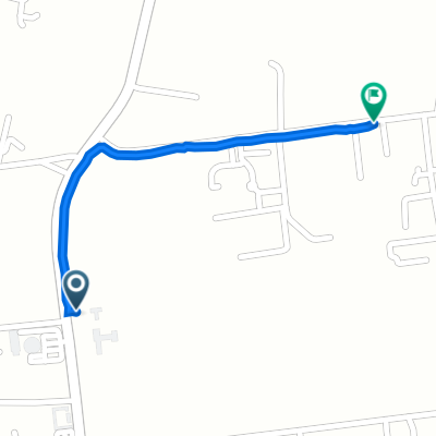
Cycling in Ngong
Discover a map of 49 cycling routes and bike trails near Ngong, created by our community.
Region portrait
Get to know Ngong
Find the right bike route for you through Ngong, where we've got 49 cycle routes to explore.
4,483 km
Tracked distance
49
Cycle routes
9,519
Population
Community
Most active users in Ngong
From our community
The best bike routes in and around Ngong
JQW2+FH4, Nairobi to JQW2+7XJ, Nairobi
Cycling route in Ngong, Kajiado County, Kenya
- 11 km
- Distance
- 184 m
- Ascent
- 167 m
- Descent
Forest Line Road to Steadmak Road, Ongata Rongai
Cycling route in Ngong, Kajiado County, Kenya
- 10.9 km
- Distance
- 101 m
- Ascent
- 274 m
- Descent
Unnamed Road, Ngong to Ongata Rongai
Cycling route in Ngong, Kajiado County, Kenya
- 11.9 km
- Distance
- 116 m
- Ascent
- 337 m
- Descent
Discover more routes
- 3 Afrika
- Distance
- 3,235.2 km
- Ascent
- 4,661 m
- Descent
- 5,285 m
- Location
- Ngong, Kajiado County, Kenya
- Slow ride in hh
- Distance
- 24.2 km
- Ascent
- 126 m
- Descent
- 310 m
- Location
- Ngong, Kajiado County, Kenya
- HPQ9+GHW, Lemelepo to JP87+H3G, Olkeri
- Distance
- 4.2 km
- Ascent
- 105 m
- Descent
- 77 m
- Location
- Ngong, Kajiado County, Kenya
- Karen to junction
- Distance
- 8.5 km
- Ascent
- 0 m
- Descent
- 26 m
- Location
- Ngong, Kajiado County, Kenya
- olkeri Karen karinde road
- Distance
- 11.4 km
- Ascent
- 59 m
- Descent
- 0 m
- Location
- Ngong, Kajiado County, Kenya
- Marist Lane/Kspca, Nairobi to Eastern Bypass, Nairobi
- Distance
- 37.5 km
- Ascent
- 99 m
- Descent
- 447 m
- Location
- Ngong, Kajiado County, Kenya
- karinde to olkeri
- Distance
- 10.6 km
- Ascent
- 144 m
- Descent
- 44 m
- Location
- Ngong, Kajiado County, Kenya
- Maasai Lodge Road, Nairobi to Hope Avenue
- Distance
- 5.3 km
- Ascent
- 23 m
- Descent
- 27 m
- Location
- Ngong, Kajiado County, Kenya