
Cycling in Golegã
Discover a map of 59 cycling routes and bike trails near Golegã, created by our community.
Region portrait
Get to know Golegã
Find the right bike route for you through Golegã, where we've got 59 cycle routes to explore. Most people get on their bikes to ride here in the months of March and April.
2,962 km
Tracked distance
59
Cycle routes
3,830
Population


From our community
The best bike routes in and around Golegã
Moderate route
Cycling route in Golegã, Santarém District, Portugal
- 82.6 km
- Distance
- 886 m
- Ascent
- 793 m
- Descent

lisboa idanha 4 dia 3
Cycling route in Golegã, Santarém District, Portugal
- 49.2 km
- Distance
- 552 m
- Ascent
- 291 m
- Descent

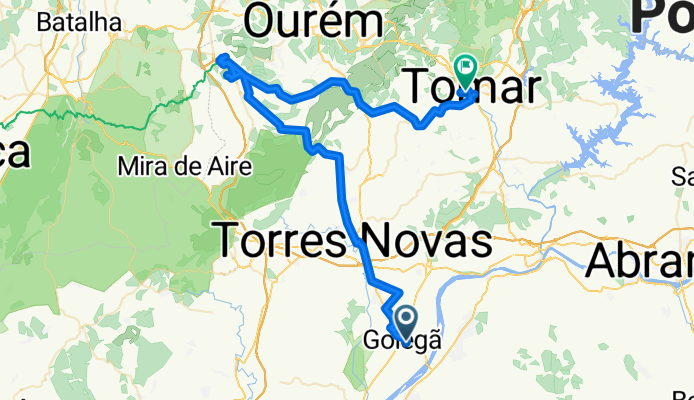
1807hh GOLEGA ALVAIAZERE
Cycling route in Golegã, Santarém District, Portugal
- 57.5 km
- Distance
- 490 m
- Ascent
- 195 m
- Descent

rota no Ribatejo?
Cycling route in Golegã, Santarém District, Portugal
- 67.9 km
- Distance
- 447 m
- Ascent
- 444 m
- Descent
Discover more routes
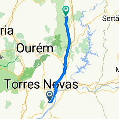
 Golegã to Alvaiázere
- Distance
- 62 km
- Ascent
- 761 m
- Descent
- 471 m
- Location
- Golegã, Santarém District, Portugal
 Day 2 | Golegã to Alvaiázere
- Distance
- 54.5 km
- Ascent
- 464 m
- Descent
- 240 m
- Location
- Golegã, Santarém District, Portugal
 3. Golega - Rabacal
- Distance
- 86.9 km
- Ascent
- 720 m
- Descent
- 569 m
- Location
- Golegã, Santarém District, Portugal
 Route from Rua Doutor Branco 5–65, Golegã
- Distance
- 143.4 km
- Ascent
- 2,343 m
- Descent
- 1,983 m
- Location
- Golegã, Santarém District, Portugal
 port 2
- Distance
- 92.7 km
- Ascent
- 1,307 m
- Descent
- 1,033 m
- Location
- Golegã, Santarém District, Portugal
 4 - Golegã - Fátima
- Distance
- 40.6 km
- Ascent
- 524 m
- Descent
- 200 m
- Location
- Golegã, Santarém District, Portugal
 7-GOLEGA-COIMBRA
- Distance
- 103.6 km
- Ascent
- 556 m
- Descent
- 559 m
- Location
- Golegã, Santarém District, Portugal
 Volta ao Distrito de Santarém - Etapa 4
- Distance
- 155.3 km
- Ascent
- 450 m
- Descent
- 382 m
- Location
- Golegã, Santarém District, Portugal