
Cycling in Watchet
Discover a map of 12 cycling routes and bike trails near Watchet, created by our community.
Region portrait
Get to know Watchet
Find the right bike route for you through Watchet, where we've got 12 cycle routes to explore.
393 km
Tracked distance
12
Cycle routes
3,793
Population

From our community
The best bike routes in and around Watchet


Doniford - Tarr Steps
Cycling route in Watchet, England, United Kingdom
Route between Doniford and Tarr Steps.
- 31.8 km
- Distance
- ---
- Ascent
- ---
- Descent
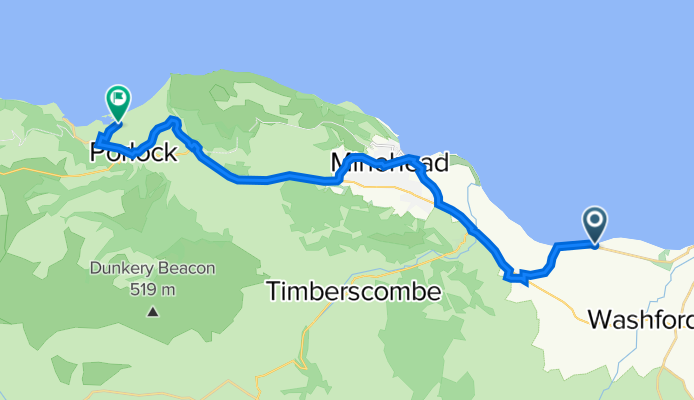
B3191, Blue Anchor, Minehead to South West Coast Path, Porlock, Minehead
Cycling route in Watchet, England, United Kingdom
- 22.3 km
- Distance
- 266 m
- Ascent
- 279 m
- Descent

The Esplanade 1 to Park Gate 5, Cheddon Fitzpaine
Cycling route in Watchet, England, United Kingdom
- 32.7 km
- Distance
- 124 m
- Ascent
- 232 m
- Descent
Discover more routes
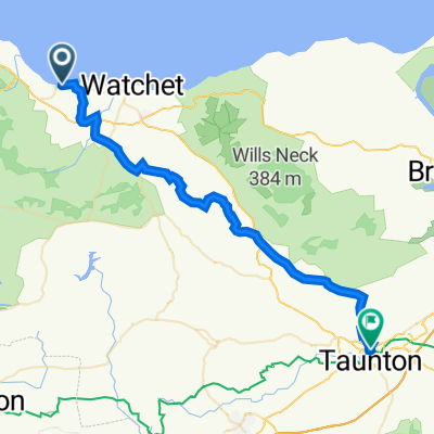 Blue Anchor Bay Road to Taunton Station Bridge
- Distance
- 35 km
- Ascent
- 367 m
- Descent
- 356 m
- Location
- Watchet, England, United Kingdom
 to school Williton middle
- Distance
- 1.8 km
- Ascent
- 0 m
- Descent
- 0 m
- Location
- Watchet, England, United Kingdom
 93–99 B3191, Blue Anchor, Minehead to Worthy Toll Road, Porlock Weir, Minehead
- Distance
- 19.4 km
- Ascent
- 298 m
- Descent
- 287 m
- Location
- Watchet, England, United Kingdom
 Minehead - Ilfracombe
- Distance
- 73 km
- Ascent
- 1,340 m
- Descent
- 1,330 m
- Location
- Watchet, England, United Kingdom
 17 Greenfield Road, Watchet to Dean's Lane, Lydeard St Lawrence, Taunton
- Distance
- 14.5 km
- Ascent
- 221 m
- Descent
- 92 m
- Location
- Watchet, England, United Kingdom
 to school watchet
- Distance
- 0.6 km
- Ascent
- 0 m
- Descent
- 0 m
- Location
- Watchet, England, United Kingdom
 aaaaaaa
- Distance
- 26.9 km
- Ascent
- 404 m
- Descent
- 397 m
- Location
- Watchet, England, United Kingdom
 Exmoor Gravel
- Distance
- 50.3 km
- Ascent
- 1,170 m
- Descent
- 1,169 m
- Location
- Watchet, England, United Kingdom