
Cycling in Ruswil
Discover a map of 104 cycling routes and bike trails near Ruswil, created by our community.
Region portrait
Get to know Ruswil
Find the right bike route for you through Ruswil, where we've got 104 cycle routes to explore. Most people get on their bikes to ride here in the months of May and July.
3,182 km
Tracked distance
104
Cycle routes
6,432
Population
Community
Most active users in Ruswil


From our community
The best bike routes in and around Ruswil

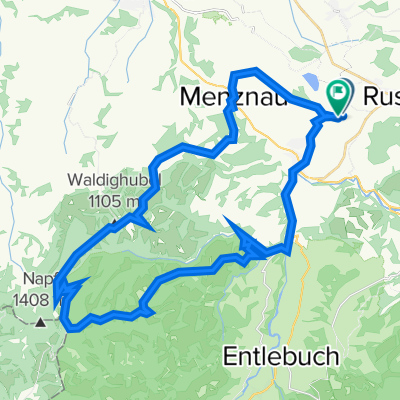
Napf by bike
Cycling route in Ruswil, Canton of Lucerne, Switzerland
- 62.2 km
- Distance
- 1,481 m
- Ascent
- 1,465 m
- Descent

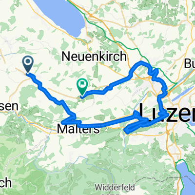
Guido Seetal
Cycling route in Ruswil, Canton of Lucerne, Switzerland
- 65.5 km
- Distance
- 729 m
- Ascent
- 729 m
- Descent

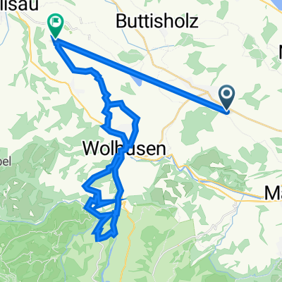
Bodenberg/Schötz
Cycling route in Ruswil, Canton of Lucerne, Switzerland
- 54.4 km
- Distance
- 437 m
- Ascent
- 432 m
- Descent

Willisau Abendrunde
Cycling route in Ruswil, Canton of Lucerne, Switzerland
- 34.9 km
- Distance
- 377 m
- Ascent
- 433 m
- Descent
Discover more routes
 23.5.
23.5.- Distance
- 17 km
- Ascent
- 304 m
- Descent
- 305 m
- Location
- Ruswil, Canton of Lucerne, Switzerland
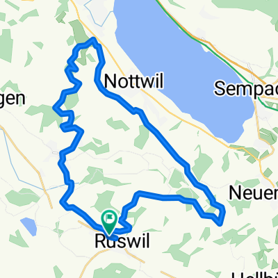
 Wolhusen-Soppensee
- Distance
- 24.6 km
- Ascent
- 293 m
- Descent
- 292 m
- Location
- Ruswil, Canton of Lucerne, Switzerland
 23.5.
23.5.- Distance
- 16.9 km
- Ascent
- 316 m
- Descent
- 317 m
- Location
- Ruswil, Canton of Lucerne, Switzerland
 Moderate Route in Ruswil
- Distance
- 44.6 km
- Ascent
- 1,068 m
- Descent
- 1,085 m
- Location
- Ruswil, Canton of Lucerne, Switzerland
 Ruswil-Menzberg-Napf-Wolhusen
- Distance
- 44.7 km
- Ascent
- 1,409 m
- Descent
- 1,428 m
- Location
- Ruswil, Canton of Lucerne, Switzerland
 Aeschfeldstrasse 17, Ruswil nach Aeschfeldstrasse 17, Ruswil
- Distance
- 29.5 km
- Ascent
- 585 m
- Descent
- 585 m
- Location
- Ruswil, Canton of Lucerne, Switzerland
 Bleischür 2, Ruswil nach Schwand 1, Willisau
- Distance
- 41.9 km
- Ascent
- 745 m
- Descent
- 742 m
- Location
- Ruswil, Canton of Lucerne, Switzerland
 Aeschfeldstrasse 16B, Ruswil nach Aeschfeldstrasse 16B, Ruswil
- Distance
- 26.1 km
- Ascent
- 528 m
- Descent
- 522 m
- Location
- Ruswil, Canton of Lucerne, Switzerland