
Cycling in Rehetobel
Discover a map of 55 cycling routes and bike trails near Rehetobel, created by our community.
Region portrait
Get to know Rehetobel
Find the right bike route for you through Rehetobel, where we've got 55 cycle routes to explore. Most people get on their bikes to ride here in the month of July.
3,584 km
Tracked distance
55
Cycle routes
1,779
Population
Community
Most active users in Rehetobel
From our community
The best bike routes in and around Rehetobel

test
Cycling route in Rehetobel, Canton of Appenzell Ausserrhoden, Switzerland
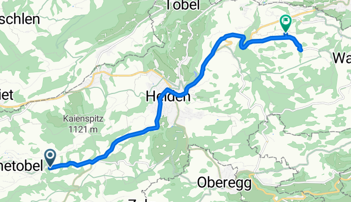
- 11.2 km
- Distance
- 355 m
- Ascent
- 354 m
- Descent

BRM 400 Teil 2
Cycling route in Rehetobel, Canton of Appenzell Ausserrhoden, Switzerland
- 101.4 km
- Distance
- 2,170 m
- Ascent
- 2,248 m
- Descent
Langsame Fahrt in
Cycling route in Rehetobel, Canton of Appenzell Ausserrhoden, Switzerland
- 9.6 km
- Distance
- 125 m
- Ascent
- 424 m
- Descent

Nasenstrasse 18, Rehetobel nach Nasenstrasse 18, Rehetobel
Cycling route in Rehetobel, Canton of Appenzell Ausserrhoden, Switzerland
- 82.1 km
- Distance
- 1,350 m
- Ascent
- 1,348 m
- Descent
Discover more routes
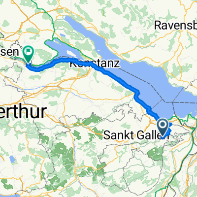 Nasenstrasse 18, Rehetobel nach Schiffländi 8, Stein am Rhein
- Distance
- 77.9 km
- Ascent
- 268 m
- Descent
- 854 m
- Location
- Rehetobel, Canton of Appenzell Ausserrhoden, Switzerland
 Nasen 18, Rehetobel nach Hauptgasse 38, Appenzell
- Distance
- 24 km
- Ascent
- 334 m
- Descent
- 536 m
- Location
- Rehetobel, Canton of Appenzell Ausserrhoden, Switzerland
 Recovered Route
- Distance
- 12.7 km
- Ascent
- 76 m
- Descent
- 662 m
- Location
- Rehetobel, Canton of Appenzell Ausserrhoden, Switzerland
 Nasenstrasse 14, Rehetobel nach Parkstraße 4, Bodman-Ludwigshafen
- Distance
- 90.9 km
- Ascent
- 565 m
- Descent
- 1,146 m
- Location
- Rehetobel, Canton of Appenzell Ausserrhoden, Switzerland
 Rehetobel - Appenzell- Gais - Stoss - Altstätten - Ruppen - St. Anton - Oberegg - Rehetobel
- Distance
- 53 km
- Ascent
- 1,116 m
- Descent
- 1,114 m
- Location
- Rehetobel, Canton of Appenzell Ausserrhoden, Switzerland
 Nasenstrasse 14, Rehetobel nach Hauptstraße 10, Bodman-Ludwigshafen
- Distance
- 90.3 km
- Ascent
- 602 m
- Descent
- 1,181 m
- Location
- Rehetobel, Canton of Appenzell Ausserrhoden, Switzerland
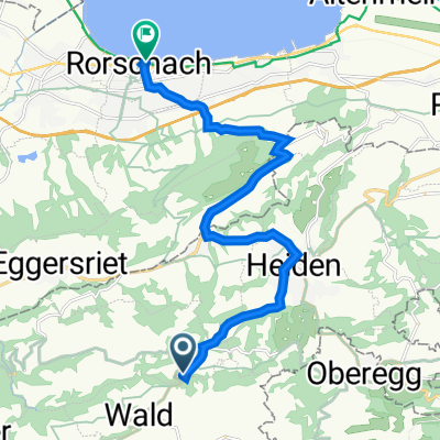 Recovered Route
- Distance
- 12.6 km
- Ascent
- 72 m
- Descent
- 657 m
- Location
- Rehetobel, Canton of Appenzell Ausserrhoden, Switzerland
 Rehetobel - Appenzell - Weissbad - Schwägalp - Urnäsch - Teufen - Rehetobel
- Distance
- 75.6 km
- Ascent
- 1,811 m
- Descent
- 1,813 m
- Location
- Rehetobel, Canton of Appenzell Ausserrhoden, Switzerland