
Cycling in Ormalingen
Discover a map of 101 cycling routes and bike trails near Ormalingen, created by our community.
Region portrait
Get to know Ormalingen
Find the right bike route for you through Ormalingen, where we've got 101 cycle routes to explore. Most people get on their bikes to ride here in the months of May and August.
3,713 km
Tracked distance
101
Cycle routes
1,803
Population
Community
Most active users in Ormalingen


From our community
The best bike routes in and around Ormalingen

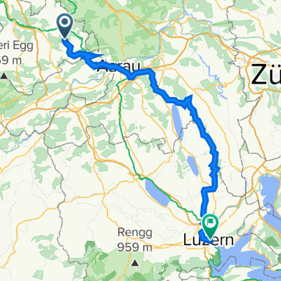
Tecknau Luzern
Cycling route in Ormalingen, Basel-Landschaft, Switzerland
- 85.8 km
- Distance
- 934 m
- Ascent
- 939 m
- Descent

Oberer und Unterer Hauenstein mit Rothrist und Kölliken
Cycling route in Ormalingen, Basel-Landschaft, Switzerland
èber den Oberen Hauenstein nach Balsthal - Oensingen. Unbedingt Abstecher in die Konditorei bei der Abzweigung nach Wolfwil machen (lohnt sich). Weiter Richtung Murgenthal - Rothenrist - Oftringen über Safenwil - Kölliken. Abzweigung Richtung Schönenwerd/Aarau im Dorf steiler Anstieg. Ab Gretzenbach nach Schönenwerd und via Winznau auf die Untere Hauensteinstrasse. Weiter über den Pass ins Homburgertal und zurück nach Hause. Alternativ ab Schönenwerd nach Aarau und über die Steffeleff oder die Salhöhe ins Baselbiet
- 114.3 km
- Distance
- 966 m
- Ascent
- 955 m
- Descent

Albtal - St. Blasien - Wehratal
Cycling route in Ormalingen, Basel-Landschaft, Switzerland
Anfahrt via Schwaderloch; Übersetzen über die schmale Rheinbrücke (keine Autos). Ab Albbruck geht es sofort in leichter Steigung hoch. Nach rund 1 km erreicht man das bewaldete Albthal. Wunderbare Bergstrecke bis hoch nach St. Blasien. Nach St. Blasien traversieren nach Todtmoos. Kleines Touristenörtchen mit feiner Bäckerei und divdrsen Restaurant. Im Sommer schön belebt. Abfahrt durch das Wehrtal nach Wehr. Von dort aus alternativ via Stein-Säckingen 11km) oder Rheinfelden (17 km) zurück in die Schweiz
- 121.2 km
- Distance
- 1,196 m
- Ascent
- 1,190 m
- Descent

Passwang - Unt. Hauenstein
Cycling route in Ormalingen, Basel-Landschaft, Switzerland
Wunderbare Rundfahrt mit Passwang und Alpensicht als Höhepunkt.
- 113.1 km
- Distance
- 1,210 m
- Ascent
- 1,204 m
- Descent
Discover more routes
 Mandach - Ampferenhöhe - Bözen
- Distance
- 75 km
- Ascent
- 1,006 m
- Descent
- 999 m
- Location
- Ormalingen, Basel-Landschaft, Switzerland
 Rothenfluh - Diegten - Langenbruck - Mümliswil - Passwang - Büsserach - Fehren - Nunningen - Reigoldswil - Oberdorf - Hölstein - Diegten - Sissach - Rothenfluh
- Distance
- 102 km
- Ascent
- 1,490 m
- Descent
- 1,490 m
- Location
- Ormalingen, Basel-Landschaft, Switzerland
 Hauenstein - Teufelsschlucht - Longbridge
- Distance
- 72.3 km
- Ascent
- 776 m
- Descent
- 783 m
- Location
- Ormalingen, Basel-Landschaft, Switzerland
 1. August-Tour Mandacherhöhe
- Distance
- 87.8 km
- Ascent
- 1,055 m
- Descent
- 1,047 m
- Location
- Ormalingen, Basel-Landschaft, Switzerland
 Schupfart - Frick - Kaisteerberg - Laufenburg - Mumpf - Kaiseraugst - Arisdorf - Windentalhöhe - Sissacher Flue - Rothenfluh
- Distance
- 86.7 km
- Ascent
- 731 m
- Descent
- 731 m
- Location
- Ormalingen, Basel-Landschaft, Switzerland
 schafmatt
- Distance
- 18.3 km
- Ascent
- 458 m
- Descent
- 468 m
- Location
- Ormalingen, Basel-Landschaft, Switzerland
 training13
- Distance
- 35.9 km
- Ascent
- 863 m
- Descent
- 863 m
- Location
- Ormalingen, Basel-Landschaft, Switzerland
 Tecknau Luzern Waldvariante
- Distance
- 87.7 km
- Ascent
- 1,451 m
- Descent
- 1,459 m
- Location
- Ormalingen, Basel-Landschaft, Switzerland