
Cycling in Gais
Discover a map of 108 cycling routes and bike trails near Gais, created by our community.
Region portrait
Get to know Gais
Find the right bike route for you through Gais, where we've got 108 cycle routes to explore. Most people get on their bikes to ride here in the months of June and July.
4,417 km
Tracked distance
108
Cycle routes
2,778
Population
Community
Most active users in Gais


From our community
The best bike routes in and around Gais
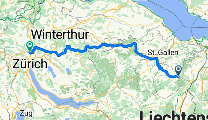
Von Schwende-Rüte bis Zürich
Cycling route in Gais, Canton of Appenzell Ausserrhoden, Switzerland
- 105.6 km
- Distance
- 1,163 m
- Ascent
- 1,775 m
- Descent
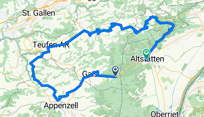
CH SG/AI/AR Altstätten-Stoss (mit Zug)-Gais-Appenzell-Stein-St.Anton-Oberegg-Altstätten (750Hm)
Cycling route in Gais, Canton of Appenzell Ausserrhoden, Switzerland
- 48.3 km
- Distance
- 947 m
- Ascent
- 1,417 m
- Descent

Samstagstour 2. Teil
Cycling route in Gais, Canton of Appenzell Ausserrhoden, Switzerland
- 25.3 km
- Distance
- 323 m
- Ascent
- 402 m
- Descent

Hirschberg Runde
Cycling route in Gais, Canton of Appenzell Ausserrhoden, Switzerland
- 19.3 km
- Distance
- 1,011 m
- Ascent
- 1,009 m
- Descent
Discover more routes
 E6: GAIS Bahnhof - ABTWIL Säntispark
- Distance
- 26 km
- Ascent
- 405 m
- Descent
- 682 m
- Location
- Gais, Canton of Appenzell Ausserrhoden, Switzerland
 A - Route 2 - Gäbris 36 km
- Distance
- 35.6 km
- Ascent
- 713 m
- Descent
- 703 m
- Location
- Gais, Canton of Appenzell Ausserrhoden, Switzerland
 Von Gais bis Zürich
- Distance
- 91 km
- Ascent
- 1,080 m
- Descent
- 1,580 m
- Location
- Gais, Canton of Appenzell Ausserrhoden, Switzerland
 Stoss-Kristallhöhle
- Distance
- 29.8 km
- Ascent
- 219 m
- Descent
- 691 m
- Location
- Gais, Canton of Appenzell Ausserrhoden, Switzerland
 Day 6 (part 2): Gais to St Gallen
- Distance
- 22 km
- Ascent
- 261 m
- Descent
- 498 m
- Location
- Gais, Canton of Appenzell Ausserrhoden, Switzerland
 vac j5
- Distance
- 54.2 km
- Ascent
- 1,171 m
- Descent
- 1,344 m
- Location
- Gais, Canton of Appenzell Ausserrhoden, Switzerland
 Stoss Gais Trogen
- Distance
- 22.9 km
- Ascent
- 372 m
- Descent
- 847 m
- Location
- Gais, Canton of Appenzell Ausserrhoden, Switzerland
 App - Lehmen - Kau - App
- Distance
- 24 km
- Ascent
- 556 m
- Descent
- 716 m
- Location
- Gais, Canton of Appenzell Ausserrhoden, Switzerland