
Cycling in Breitenwang
Discover a map of 102 cycling routes and bike trails near Breitenwang, created by our community.
Region portrait
Get to know Breitenwang
Find the right bike route for you through Breitenwang, where we've got 102 cycle routes to explore. Most people get on their bikes to ride here in the months of July and August.
5,788 km
Tracked distance
102
Cycle routes
1,532
Population


From our community
The best bike routes in and around Breitenwang


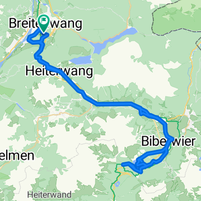
🚴♀️E*Bike🇦🇹 5.Tag Vom Hotel Thannheimertal Radweg 29.06.18.
Cycling route in Breitenwang, Tyrol, Austria
- 33.1 km
- Distance
- 373 m
- Ascent
- 147 m
- Descent


Discover more routes
 Vogel 1
- Distance
- 95.6 km
- Ascent
- 1,329 m
- Descent
- 899 m
- Location
- Breitenwang, Tyrol, Austria
 Plansee-Runde
- Distance
- 92.2 km
- Ascent
- 890 m
- Descent
- 887 m
- Location
- Breitenwang, Tyrol, Austria
 Allgäuer Seenrunde
- Distance
- 95.2 km
- Ascent
- 431 m
- Descent
- 433 m
- Location
- Breitenwang, Tyrol, Austria
 ALPENRUNDFAHRT 001: Reutte - VIA - INN - Achensee - Sylvenstein - Isar - Garmisch - Oberau - Ettal - Ammersattel - Plansee -Reutte
- Distance
- 293.1 km
- Ascent
- 1,447 m
- Descent
- 1,447 m
- Location
- Breitenwang, Tyrol, Austria
 Blindseerunde ab Reutte
- Distance
- 88.9 km
- Ascent
- 1,378 m
- Descent
- 1,378 m
- Location
- Breitenwang, Tyrol, Austria
 Reute>Fernpass>zurück
- Distance
- 64.4 km
- Ascent
- 830 m
- Descent
- 830 m
- Location
- Breitenwang, Tyrol, Austria
 Um das Hochjoch
- Distance
- 21 km
- Ascent
- 596 m
- Descent
- 596 m
- Location
- Breitenwang, Tyrol, Austria
 kuhklause plansee
- Distance
- 22.4 km
- Ascent
- 814 m
- Descent
- 812 m
- Location
- Breitenwang, Tyrol, Austria