
Cycling in Bachmanning
Discover a map of 173 cycling routes and bike trails near Bachmanning, created by our community.
Region portrait
Get to know Bachmanning
Find the right bike route for you through Bachmanning, where we've got 173 cycle routes to explore. Most people get on their bikes to ride here in the months of May and June.
10,285 km
Tracked distance
173
Cycle routes
Community
Most active users in Bachmanning


From our community
The best bike routes in and around Bachmanning

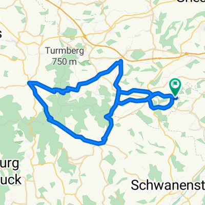
Traun-Alm Runde
Cycling route in Bachmanning, Upper Austria, Austria
- 120.4 km
- Distance
- 1,146 m
- Ascent
- 1,146 m
- Descent

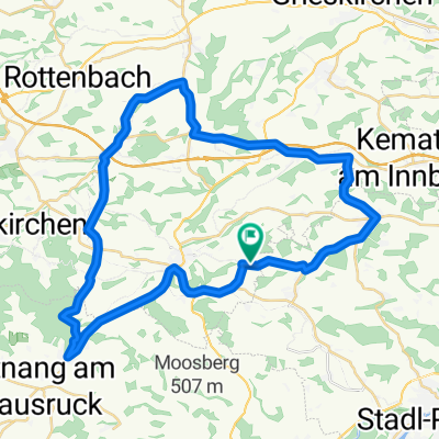
Hausruckrunde über Pich/Wels
Cycling route in Bachmanning, Upper Austria, Austria
- 82.8 km
- Distance
- 885 m
- Ascent
- 885 m
- Descent

OBK Pichl/Krailberg MBike
Cycling route in Bachmanning, Upper Austria, Austria
- 17.3 km
- Distance
- 215 m
- Ascent
- 393 m
- Descent

Ab ins Innviertel
Cycling route in Bachmanning, Upper Austria, Austria
- 83.7 km
- Distance
- 1,094 m
- Ascent
- 1,086 m
- Descent
Discover more routes
 Königmairgut
- Distance
- 11.5 km
- Ascent
- 164 m
- Descent
- 139 m
- Location
- Bachmanning, Upper Austria, Austria
 Route 2 Kraftausdauer
- Distance
- 52.6 km
- Ascent
- 1,035 m
- Descent
- 1,017 m
- Location
- Bachmanning, Upper Austria, Austria
 Hausruckrunde
- Distance
- 58.2 km
- Ascent
- 679 m
- Descent
- 714 m
- Location
- Bachmanning, Upper Austria, Austria
 Haager Lies Radweg Bachmaning - Haag - R21 Hofkirchen - Aistersheim - Gaspoltshofen - R106 Hundhagen
- Distance
- 61.6 km
- Ascent
- 754 m
- Descent
- 778 m
- Location
- Bachmanning, Upper Austria, Austria
 Hausruckrunde CLONED FROM ROUTE 433084
- Distance
- 58.2 km
- Ascent
- 679 m
- Descent
- 714 m
- Location
- Bachmanning, Upper Austria, Austria
 Bachmanning-Offenhausen-Gaspoltshofen
- Distance
- 48.3 km
- Ascent
- 882 m
- Descent
- 845 m
- Location
- Bachmanning, Upper Austria, Austria
 Bachmanning-Kasberg
- Distance
- 93 km
- Ascent
- 1,826 m
- Descent
- 1,726 m
- Location
- Bachmanning, Upper Austria, Austria
 Route 4 Schnellkraft
- Distance
- 42.3 km
- Ascent
- 542 m
- Descent
- 533 m
- Location
- Bachmanning, Upper Austria, Austria