
Cycling in Wiesenthau
Discover a map of 50 cycling routes and bike trails near Wiesenthau, created by our community.
Region portrait
Get to know Wiesenthau
Find the right bike route for you through Wiesenthau, where we've got 50 cycle routes to explore.
4,619 km
Tracked distance
50
Cycle routes
1,711
Population
Community
Most active users in Wiesenthau

From our community
The best bike routes in and around Wiesenthau

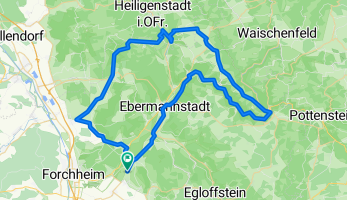
Forchheim - Muggendorf - hängender Stein
Cycling route in Wiesenthau, Bavaria, Germany
- 43.1 km
- Distance
- 707 m
- Ascent
- 684 m
- Descent

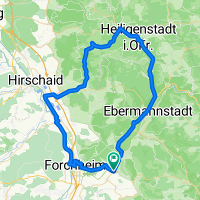
Mühlenhof - Pretzfeld - Ebermannstadt - Mühlenhof
Cycling route in Wiesenthau, Bavaria, Germany
- 19.5 km
- Distance
- 65 m
- Ascent
- 59 m
- Descent
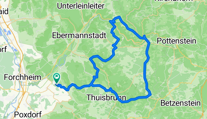
Von Kirchehrenbach über Tiefenstürming in's Wiesenttal
Cycling route in Wiesenthau, Bavaria, Germany
- 67.6 km
- Distance
- 615 m
- Ascent
- 614 m
- Descent
eine schöne kleine runde durch die fränkische CLONED FROM ROUTE 261440
Cycling route in Wiesenthau, Bavaria, Germany
- 64.2 km
- Distance
- 943 m
- Ascent
- 943 m
- Descent
Discover more routes
 Durch die Bärenschlucht
- Distance
- 94.3 km
- Ascent
- 795 m
- Descent
- 793 m
- Location
- Wiesenthau, Bavaria, Germany
 Raubritter Tour
- Distance
- 30.9 km
- Ascent
- 496 m
- Descent
- 379 m
- Location
- Wiesenthau, Bavaria, Germany
 Fränkische Schweiz ab Forchheim - Reuth
- Distance
- 51.2 km
- Ascent
- 731 m
- Descent
- 613 m
- Location
- Wiesenthau, Bavaria, Germany
 Rundtour Wiesenthau - Glückstadt - Hirschaid
- Distance
- 61.1 km
- Ascent
- 334 m
- Descent
- 325 m
- Location
- Wiesenthau, Bavaria, Germany
 After Work Sonnenuntergangstour
- Distance
- 9.5 km
- Ascent
- 284 m
- Descent
- 273 m
- Location
- Wiesenthau, Bavaria, Germany
 Feierabendrunde
- Distance
- 41.2 km
- Ascent
- 354 m
- Descent
- 336 m
- Location
- Wiesenthau, Bavaria, Germany
 FaC #25 Wiesenthau - Hundsboden
- Distance
- 7 km
- Ascent
- 240 m
- Descent
- 62 m
- Location
- Wiesenthau, Bavaria, Germany
 FaC Rund ums Waberla
- Distance
- 9.5 km
- Ascent
- 107 m
- Descent
- 44 m
- Location
- Wiesenthau, Bavaria, Germany