
Cycling in Themar
Discover a map of 34 cycling routes and bike trails near Themar, created by our community.
Region portrait
Get to know Themar
Find the right bike route for you through Themar, where we've got 34 cycle routes to explore.
2,588 km
Tracked distance
34
Cycle routes
3,083
Population


From our community
The best bike routes in and around Themar

13:07:23 Themar-Bad Salzungen
Cycling route in Themar, Free State of Thuringia, Germany
noch in Bearbeitung
von
<font face="Arial, sans-serif"><font size="2">http://www.bikemap.net/de/route/2283067-130722-neuhaus-am-rennsteig-themar/?newly_saved=true
- 67.7 km
- Distance
- 253 m
- Ascent
- 348 m
- Descent

Schöne Südtühringen Runde
Cycling route in Themar, Free State of Thuringia, Germany
Start ist in Themar(98660). Man kann mit dem Auto anreisen (Parken auf dem TEGUT-Parkplatz) oder mit der Bahn (Tour beginnt und endet in der Nähe vom Bahnhof).Die Tour enthält ca. 20% Asphaltstrecke und der Rest sind breite Schotter- und Waldwege. Das erste Waldstück ist die Auffahrt zum Feldstei
- 32.7 km
- Distance
- 624 m
- Ascent
- 621 m
- Descent

Werratal Etappe2
Cycling route in Themar, Free State of Thuringia, Germany
Themar - Meiningen-Vacha
- 87.8 km
- Distance
- 273 m
- Ascent
- 362 m
- Descent

Keltenweg Themar - Bad Königshofen
Cycling route in Themar, Free State of Thuringia, Germany
Routenverlauf:<br /><br />Themar - Kloster Veßra - Grimmelshausen - Trostadt - Reurieth - Dingsleben - Haina - Römhild - Milz - Hindfeld - Eicha - Trappstadt - Eyershausen - Ipthausen - Bad Königshofen i. Grabfeld.<br /><br />Streckenbeschreibung:<
- 42 km
- Distance
- 322 m
- Ascent
- 373 m
- Descent
Discover more routes
 Themar-Hochrhön-Kreuzberg-Themar
- Distance
- 174.4 km
- Ascent
- 2,103 m
- Descent
- 2,101 m
- Location
- Themar, Free State of Thuringia, Germany
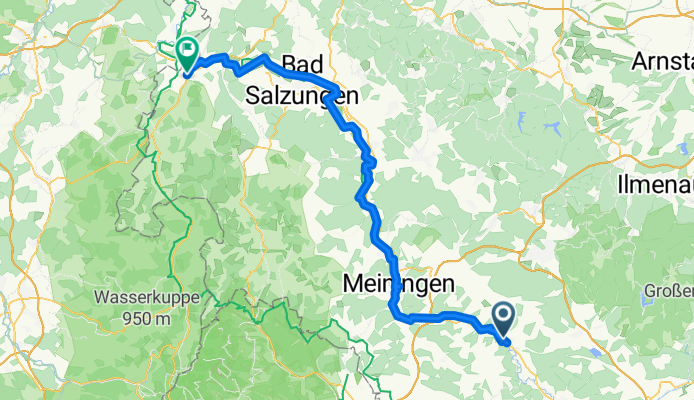
 Themar - Bad Salzungen
- Distance
- 63.9 km
- Ascent
- 302 m
- Descent
- 390 m
- Location
- Themar, Free State of Thuringia, Germany
 Themar-HBN-Sachsenbrunn-Schleu-Themar
- Distance
- 80.2 km
- Ascent
- 561 m
- Descent
- 503 m
- Location
- Themar, Free State of Thuringia, Germany
 Themar-Werraquelle-Themar
- Distance
- 100.4 km
- Ascent
- 758 m
- Descent
- 758 m
- Location
- Themar, Free State of Thuringia, Germany
 20160913_114532.gpx
- Distance
- 61.4 km
- Ascent
- 174 m
- Descent
- 264 m
- Location
- Themar, Free State of Thuringia, Germany
 Themar - Oberhof
- Distance
- 55.9 km
- Ascent
- 944 m
- Descent
- 422 m
- Location
- Themar, Free State of Thuringia, Germany
 Werratour
- Distance
- 29.7 km
- Ascent
- 228 m
- Descent
- 120 m
- Location
- Themar, Free State of Thuringia, Germany
 20140725_125645.gpx
- Distance
- 44.2 km
- Ascent
- 394 m
- Descent
- 476 m
- Location
- Themar, Free State of Thuringia, Germany