
Cycling in Stulln
Discover a map of 46 cycling routes and bike trails near Stulln, created by our community.
Region portrait
Get to know Stulln
Find the right bike route for you through Stulln, where we've got 46 cycle routes to explore. Most people get on their bikes to ride here in the month of July.
2,266 km
Tracked distance
46
Cycle routes
1,683
Population
Community
Most active users in Stulln


From our community
The best bike routes in and around Stulln

Firmenradtour 2019 Schwarzachtal-Radweg nach Ovi
Cycling route in Stulln, Bavaria, Germany
- 49.2 km
- Distance
- 218 m
- Ascent
- 216 m
- Descent

Ritz-Rundfahrt
Cycling route in Stulln, Bavaria, Germany
Strecke ist auch für Freizeitfahrer geeignet, schöne ländliche Landschaft, Mit etwas Glück, können auch Wildtiere entlang der Strecke beobachtet werden
Start ist bei der Bäckerei Ritz
dann in Richtung Nabburg
am Ortsende links und den flachen Anstieg, dannach den Berg rechts immer Richtung Nabburg
danach Richtung Bergelshof, nun nur den Strassenverlauf folgen.
ab Lissenthann kommt eine längeres Gefälle zum Erholen
In Trisching über die Strasse fahren, nach der Kirche links Strasse im See
Nun gehts Richtung Schmidgaden
auf der linken Seite kommt ein Dammwildgehege
in Schmidgaden wieder links den Anstieg hinauf
dann wieder Rechts Richtung Nabburg
Nach der Fischzucht in einen kleinen Feldweg Richtung Stulln
Ziel ist wieder die Bäckerei Ritz
- 23 km
- Distance
- 234 m
- Ascent
- 232 m
- Descent

Oberpfälzer-Wald-Runde Teil1
Cycling route in Stulln, Bavaria, Germany
Wölsendorf, Naabtal bis Neustadt an der Waldnaab, Bockl-Bahntrasse bis Pleystein (Übernachtung)
- 85.2 km
- Distance
- 404 m
- Ascent
- 232 m
- Descent
Discover more routes
 Oberpfälzer Waldrunde
- Distance
- 156 km
- Ascent
- 571 m
- Descent
- 572 m
- Location
- Stulln, Bavaria, Germany
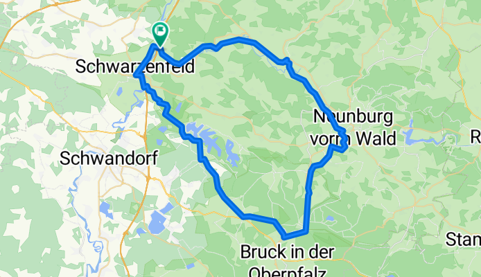
 Stulln-Neunburg-Stulln
- Distance
- 51.9 km
- Ascent
- 276 m
- Descent
- 276 m
- Location
- Stulln, Bavaria, Germany
 Quer_durchs_Oberpflzer_Seenland
- Distance
- 59.5 km
- Ascent
- 364 m
- Descent
- 365 m
- Location
- Stulln, Bavaria, Germany
 Cyklodovolená 2017 7.den
- Distance
- 87.8 km
- Ascent
- 606 m
- Descent
- 453 m
- Location
- Stulln, Bavaria, Germany
 Bahntrasse
- Distance
- 59.4 km
- Ascent
- 277 m
- Descent
- 277 m
- Location
- Stulln, Bavaria, Germany
 2018 Oberpfälzer Seenland
- Distance
- 59.6 km
- Ascent
- 265 m
- Descent
- 264 m
- Location
- Stulln, Bavaria, Germany
 Stulln-Gleiritsch-Stulln
- Distance
- 40.8 km
- Ascent
- 367 m
- Descent
- 370 m
- Location
- Stulln, Bavaria, Germany
 Bayerisch-Böhmischer-Freundschaftsradweg
- Distance
- 19.6 km
- Ascent
- 136 m
- Descent
- 137 m
- Location
- Stulln, Bavaria, Germany