
Cycling in Schwandorf in Bayern
Discover a map of 346 cycling routes and bike trails near Schwandorf in Bayern, created by our community.
Region portrait
Get to know Schwandorf in Bayern
Find the right bike route for you through Schwandorf in Bayern, where we've got 346 cycle routes to explore. Most people get on their bikes to ride here in the months of May and August.
16,915 km
Tracked distance
346
Cycle routes
28,235
Population
Community
Most active users in Schwandorf in Bayern


From our community
The best bike routes in and around Schwandorf in Bayern

Von Schwandorf bis Teublitz
Cycling route in Schwandorf in Bayern, Bavaria, Germany
- 11.6 km
- Distance
- 104 m
- Ascent
- 106 m
- Descent

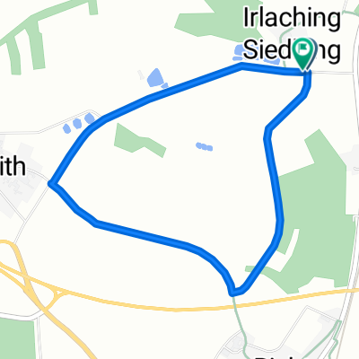
Zur Alten Hochstraße
Cycling route in Schwandorf in Bayern, Bavaria, Germany
Eine kurze Runde für die Mittagspause oder zum Feierabend.
Anfangs- und Endpunkt ist die Einmündung der Wöhrangerstraße in die Ettmannsdorfer Straße unmittelbar westlich der Naabbrücke. Die Route führt entgegen dem Uhrzeigersinn auf die Jurahöhen westlich von Naabeck. Bis Hartenricht ist d
- 19.4 km
- Distance
- 207 m
- Ascent
- 207 m
- Descent

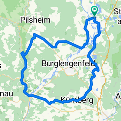
Drei-Schlösser-Runde
Cycling route in Schwandorf in Bayern, Bavaria, Germany
Die Route beginnt und endet in Schwandorf an der Einmündung der Krondorfer Straße in die Nürnberger Straße. In unmittelbarer Nähe auf dem Festplatz am Angerring besteht kostenlose Parkmöglichkeit, ausgenommen während des Volksfestes in der Woche nach Christ
- 55.7 km
- Distance
- 398 m
- Ascent
- 398 m
- Descent

B2-4/Saale 4a kurz: Ettmannsdorf-West - Weiden, Am Tor, 57,4km, 170hm
Cycling route in Schwandorf in Bayern, Bavaria, Germany
Ettmannsdorf-West/Schwandorf - (Naabtal-Radweg) - Krondorf - Irrenlohe - Schwarzenfeld - Wölsendorf mit Badestelle?? - Nabburg - Untersteinbach - Badestelle Wernberg - Wernberg-Köblitz - Kettnitzmühle - Grünau - Luhe-Wildenau - (Waldnaab-Radweg) - Pirk - Rothenstadt - Weiden i
- 57.4 km
- Distance
- 256 m
- Ascent
- 240 m
- Descent
Discover more routes
 Saale 4 kurz: Schwandorf - Kotzenbach, Gasthaus Mois, 70,5km, 271hm
- Distance
- 70.8 km
- Ascent
- 230 m
- Descent
- 183 m
- Location
- Schwandorf in Bayern, Bavaria, Germany
 Oberpfälzisch-Fränkische Jakobsweg
- Distance
- 123.1 km
- Ascent
- 745 m
- Descent
- 801 m
- Location
- Schwandorf in Bayern, Bavaria, Germany
 Angerring 35, Schwandorf nach Angerring 34, Schwandorf
- Distance
- 17.4 km
- Ascent
- 199 m
- Descent
- 198 m
- Location
- Schwandorf in Bayern, Bavaria, Germany
 Richter Berg Ka1, 1,5km, 45HM
- Distance
- 3.8 km
- Ascent
- 58 m
- Descent
- 55 m
- Location
- Schwandorf in Bayern, Bavaria, Germany
 Kallmünz übers Vilstal
- Distance
- 57.9 km
- Ascent
- 330 m
- Descent
- 333 m
- Location
- Schwandorf in Bayern, Bavaria, Germany
 Rund um Naabeck
- Distance
- 18.7 km
- Ascent
- 159 m
- Descent
- 159 m
- Location
- Schwandorf in Bayern, Bavaria, Germany
 Kallmünz übers Vilstal
- Distance
- 57.9 km
- Ascent
- 340 m
- Descent
- 343 m
- Location
- Schwandorf in Bayern, Bavaria, Germany
 Einfürungstour / Sa 30.06.2012
- Distance
- 31.9 km
- Ascent
- 230 m
- Descent
- 230 m
- Location
- Schwandorf in Bayern, Bavaria, Germany