
Cycling in Sankt Martin
Discover a map of 236 cycling routes and bike trails near Sankt Martin, created by our community.
Region portrait
Get to know Sankt Martin
Find the right bike route for you through Sankt Martin, where we've got 236 cycle routes to explore. Most people get on their bikes to ride here in the months of May and August.
8,194 km
Tracked distance
236
Cycle routes
1,872
Population
Community
Most active users in Sankt Martin


From our community
The best bike routes in and around Sankt Martin

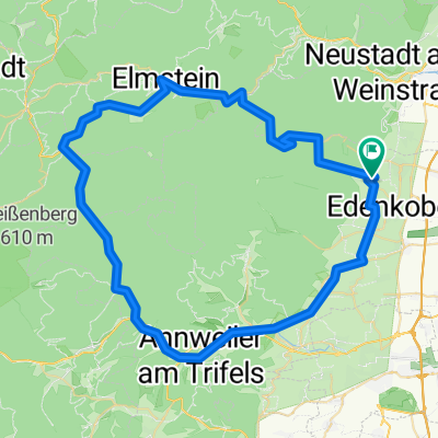
Einmal um den Kalmit
Cycling route in Sankt Martin, Rhineland-Palatinate, Germany
Startpunkt P AV Schneider den Wanderweg durch St. Martin zur zur Einlaubstrasse folgen und dann geht der Asphalt in Schotter über. Dem ansteigenden Weg bis zum Anschluß an die Totenkopfstrasse folgen, dort wird auf den Wanderweg gewechselt...steil...steinig...Schiebepassage. Dann gehts weiter zum
- 12.4 km
- Distance
- 392 m
- Ascent
- 392 m
- Descent

Edenkobener Radpfad durch Forst bis Römische Wachstube von Hawai
Cycling route in Sankt Martin, Rhineland-Palatinate, Germany
Schöner. breiter Waldweg um Edenkoben und St. Martin für MTB und X-Bike mit Asphaltabfahrt über die Totenkopfstr. Die Aufzeichnung beginnt Edenkoben am Werderberg. Noch ein paar hundert Meter passiert der Pfad den Abzweig zum Friedensdenkmal auf dem Werderberg selbst. Dann geht's
- 15.3 km
- Distance
- 284 m
- Ascent
- 453 m
- Descent

Einrollen vum Mann mit de Kapp...
Cycling route in Sankt Martin, Rhineland-Palatinate, Germany
Ab Maikammer durch die Südpfalz bis Heuchelheim und dann über Weinstraße mit Abstecher über 3 Buchen/Heldenstein wieder retour...
- 73.5 km
- Distance
- 946 m
- Ascent
- 946 m
- Descent

20170325_Pfaelzer_Wald_Runde
Cycling route in Sankt Martin, Rhineland-Palatinate, Germany
Nette Runde quer durch den Pfäler Wald
- 25.6 km
- Distance
- 919 m
- Ascent
- 919 m
- Descent
Discover more routes
 Einfache Fahrt Totenkopfhütte
- Distance
- 2.8 km
- Ascent
- 76 m
- Descent
- 107 m
- Location
- Sankt Martin, Rhineland-Palatinate, Germany
 9.10.2019
- Distance
- 11.2 km
- Ascent
- 321 m
- Descent
- 273 m
- Location
- Sankt Martin, Rhineland-Palatinate, Germany
 Hausrunde
- Distance
- 21.5 km
- Ascent
- 868 m
- Descent
- 868 m
- Location
- Sankt Martin, Rhineland-Palatinate, Germany
 05-MRZ-11
- Distance
- 13.5 km
- Ascent
- 561 m
- Descent
- 560 m
- Location
- Sankt Martin, Rhineland-Palatinate, Germany
 Tag_2
Tag_2- Distance
- 63.4 km
- Ascent
- 1,121 m
- Descent
- 1,122 m
- Location
- Sankt Martin, Rhineland-Palatinate, Germany
 St.Martin - Hermersberger Hof
- Distance
- 79.4 km
- Ascent
- 899 m
- Descent
- 899 m
- Location
- Sankt Martin, Rhineland-Palatinate, Germany
 Über Anweiler nach Steinborn
- Distance
- 80.5 km
- Ascent
- 696 m
- Descent
- 712 m
- Location
- Sankt Martin, Rhineland-Palatinate, Germany
 St Martin Ritt durch die Pfalz
- Distance
- 69 km
- Ascent
- 830 m
- Descent
- 834 m
- Location
- Sankt Martin, Rhineland-Palatinate, Germany