
Cycling in Münchenbernsdorf
Discover a map of 37 cycling routes and bike trails near Münchenbernsdorf, created by our community.
Region portrait
Get to know Münchenbernsdorf
Find the right bike route for you through Münchenbernsdorf, where we've got 37 cycle routes to explore.
4,802 km
Tracked distance
37
Cycle routes
3,450
Population
Community
Most active users in Münchenbernsdorf


From our community
The best bike routes in and around Münchenbernsdorf

Münchenbernsdorf - Via Claudia Augusta
Cycling route in Münchenbernsdorf, Free State of Thuringia, Germany
Verbindung zur alten Römerstraße nach Venedig oder Ostiglia. Die Strecke ist bis Mönchberg gut auf dem Saaleradweg befahrbar, den ich in der Karte allerdings nicht verfolgt habe!<br />Bis auf den Saaleradweg ist die Strecke relativ dicht befahren, dafür aber eine direkte Verbindung nach Don
- 369 km
- Distance
- 1,383 m
- Ascent
- 1,297 m
- Descent

Training 4
Cycling route in Münchenbernsdorf, Free State of Thuringia, Germany
...
- 100 km
- Distance
- 622 m
- Ascent
- 612 m
- Descent

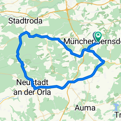
Zeulenroda-Landschaftsausflug
Cycling route in Münchenbernsdorf, Free State of Thuringia, Germany
Großteils wenigbefahrene, einwandfreie Straßen mit schönem Ausblick und ein paar schönen, wenn auch kurzen Anstiegen als auch manchen schnellen Abfahrten.<br />
Für jeden geeignet. So auch mit unzähligen Rastmöglichkeiten
- 69.9 km
- Distance
- 575 m
- Ascent
- 575 m
- Descent
Münchenbernsdorf-Leegebruch 2013
Cycling route in Münchenbernsdorf, Free State of Thuringia, Germany
kaum Berge, fast nur Bundesstraße, triste Landschaft
- 282.1 km
- Distance
- 291 m
- Ascent
- 578 m
- Descent
Discover more routes
 Training-Eisenberg
- Distance
- 79.8 km
- Ascent
- 454 m
- Descent
- 454 m
- Location
- Münchenbernsdorf, Free State of Thuringia, Germany
 JMR Münchenbernsdorf
- Distance
- 4.7 km
- Ascent
- 52 m
- Descent
- 52 m
- Location
- Münchenbernsdorf, Free State of Thuringia, Germany
 JMR Münchenbernsdorf
- Distance
- 4.7 km
- Ascent
- 52 m
- Descent
- 52 m
- Location
- Münchenbernsdorf, Free State of Thuringia, Germany
 Training(Neustadt-Stadtroda-Klosterlausnitz-Kraftsdorf-St. Gangloff-Münchenbernsdorf)
- Distance
- 119 km
- Ascent
- 824 m
- Descent
- 823 m
- Location
- Münchenbernsdorf, Free State of Thuringia, Germany
 Münchenbernsdorf- Remptendorf
- Distance
- 56.3 km
- Ascent
- 532 m
- Descent
- 399 m
- Location
- Münchenbernsdorf, Free State of Thuringia, Germany
 Winterstrecke (kurz)
- Distance
- 57.6 km
- Ascent
- 455 m
- Descent
- 435 m
- Location
- Münchenbernsdorf, Free State of Thuringia, Germany
 ndp ffw
- Distance
- 8.2 km
- Ascent
- 53 m
- Descent
- 86 m
- Location
- Münchenbernsdorf, Free State of Thuringia, Germany
 Pfingstrunde
- Distance
- 38.2 km
- Ascent
- 255 m
- Descent
- 256 m
- Location
- Münchenbernsdorf, Free State of Thuringia, Germany