
Cycling in Mellrichstadt
Discover a map of 95 cycling routes and bike trails near Mellrichstadt, created by our community.
Region portrait
Get to know Mellrichstadt
Find the right bike route for you through Mellrichstadt, where we've got 95 cycle routes to explore. Most people get on their bikes to ride here in the months of May and June.
4,407 km
Tracked distance
95
Cycle routes
6,254
Population
Community
Most active users in Mellrichstadt


From our community
The best bike routes in and around Mellrichstadt

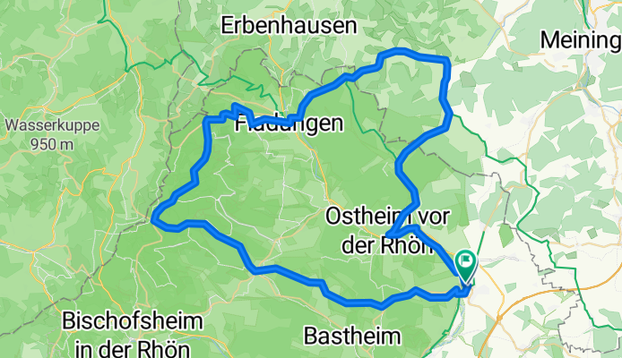
Mellrichstadt-Hollstadt Rundkurs
Cycling route in Mellrichstadt, Bavaria, Germany
- 28.6 km
- Distance
- 255 m
- Ascent
- 242 m
- Descent

Truppenübungsplatz MET2
Cycling route in Mellrichstadt, Bavaria, Germany
- 16.3 km
- Distance
- 196 m
- Ascent
- 185 m
- Descent
RHÖN_Mellrichstadt_LangeRhön
Cycling route in Mellrichstadt, Bavaria, Germany
- 73.3 km
- Distance
- 868 m
- Ascent
- 878 m
- Descent

frickenhäuser runde 2
Cycling route in Mellrichstadt, Bavaria, Germany
- 19.2 km
- Distance
- 229 m
- Ascent
- 229 m
- Descent
Discover more routes
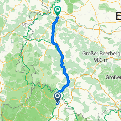
 MET-A71
- Distance
- 24.2 km
- Ascent
- 210 m
- Descent
- 210 m
- Location
- Mellrichstadt, Bavaria, Germany
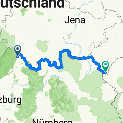
 BY_HE_Mellrichst_Milseburg_Obersinn
- Distance
- 137.3 km
- Ascent
- 957 m
- Descent
- 1,023 m
- Location
- Mellrichstadt, Bavaria, Germany
 Truppenübungsplatz MET
- Distance
- 18.5 km
- Ascent
- 141 m
- Descent
- 140 m
- Location
- Mellrichstadt, Bavaria, Germany
 Grünes Band
- Distance
- 291.6 km
- Ascent
- 1,676 m
- Descent
- 1,221 m
- Location
- Mellrichstadt, Bavaria, Germany
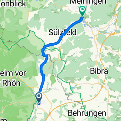 Mellrichstadt-Meinigen
- Distance
- 18.7 km
- Ascent
- 232 m
- Descent
- 198 m
- Location
- Mellrichstadt, Bavaria, Germany
 6/München-Bremen
- Distance
- 79.6 km
- Ascent
- 510 m
- Descent
- 578 m
- Location
- Mellrichstadt, Bavaria, Germany
 Mellrichstadt bis Burgwallbacher See
- Distance
- 29.7 km
- Ascent
- 324 m
- Descent
- 280 m
- Location
- Mellrichstadt, Bavaria, Germany
 stedtlingen-mellrichstadt
- Distance
- 14.5 km
- Ascent
- 219 m
- Descent
- 109 m
- Location
- Mellrichstadt, Bavaria, Germany