
Cycling in Lichtentanne
Discover a map of 191 cycling routes and bike trails near Lichtentanne, created by our community.
Region portrait
Get to know Lichtentanne
Find the right bike route for you through Lichtentanne, where we've got 191 cycle routes to explore. Most people get on their bikes to ride here in the months of May and June.
8,393 km
Tracked distance
191
Cycle routes
7,163
Population
Community
Most active users in Lichtentanne


Handpicked routes
Discover Lichtentanne through these collections
Tour
From our community
The best bike routes in and around Lichtentanne

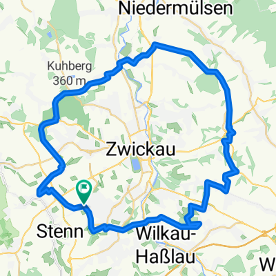
Rundfahrt Zwickau - Zschorlau
Cycling route in Lichtentanne, Saxony, Germany
Schöne Rundtour mit dem Mountainbike über größtenteils Autofreie Wege durch den Forst.
- 61.1 km
- Distance
- 803 m
- Ascent
- 803 m
- Descent

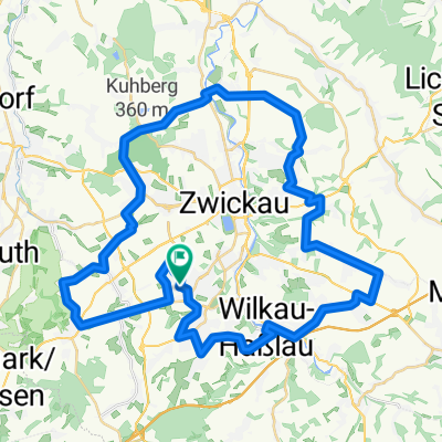
Marienthal - Niederschindmaas
Cycling route in Lichtentanne, Saxony, Germany
Familien tauglich
-VORSICHT : ...auf dem Mulderadweg von Zwickau bis Mosel - viele Fußgänger und auch beklop. Radfahrer in Mengen unterwegs
- 18.4 km
- Distance
- 0 m
- Ascent
- 79 m
- Descent

Huegelig Kirchberg Niedercrinitz Rottmannsdorf
Cycling route in Lichtentanne, Saxony, Germany
Alternative meiner kleinen Trainingsrunde, weniger Höhenmeter, ab Krankenhaus Kirchberg Einstieg in den Forst in Richtung Erzgebirgskamm möglich. Route ist auch bei Schlechtwetter gut fahrbar mit klienen Optionen
- 35.7 km
- Distance
- 542 m
- Ascent
- 542 m
- Descent

Zwickau/Planitz - Mülsengrund und zurück
Cycling route in Lichtentanne, Saxony, Germany
Teilweise ist die Streckenführung durch städtische Baumaßnahmen verändert (ist auch eine ältere Karte), aber wenn man fährt, erklärt sich der Weg von selbst.
- 40.1 km
- Distance
- 258 m
- Ascent
- 304 m
- Descent
Discover more routes
 Männertag 2015
- Distance
- 286.4 km
- Ascent
- 202 m
- Descent
- 408 m
- Location
- Lichtentanne, Saxony, Germany
 Rund um Zwickau ( Kl. Runde )
- Distance
- 39.2 km
- Ascent
- 422 m
- Descent
- 426 m
- Location
- Lichtentanne, Saxony, Germany
 Rund um Zwickau
- Distance
- 49.9 km
- Ascent
- 547 m
- Descent
- 547 m
- Location
- Lichtentanne, Saxony, Germany
 Thanhof-Kirchberg-Eibenstock-Auerbach-Lengenfeld-Gospersgrün
- Distance
- 87.6 km
- Ascent
- 786 m
- Descent
- 786 m
- Location
- Lichtentanne, Saxony, Germany
 Zwickau - Auersberg - Zwickau
- Distance
- 109.6 km
- Ascent
- 1,248 m
- Descent
- 1,248 m
- Location
- Lichtentanne, Saxony, Germany
 Zwickau - Kirchberg
- Distance
- 33.9 km
- Ascent
- 280 m
- Descent
- 304 m
- Location
- Lichtentanne, Saxony, Germany
 Thanhof-Schmölln-Lucka-Leipzig
- Distance
- 83.9 km
- Ascent
- 167 m
- Descent
- 403 m
- Location
- Lichtentanne, Saxony, Germany
 Waldkirchen Tourplan
- Distance
- 36.8 km
- Ascent
- 439 m
- Descent
- 439 m
- Location
- Lichtentanne, Saxony, Germany