
Cycling in Lehrensteinsfeld
Discover a map of 233 cycling routes and bike trails near Lehrensteinsfeld, created by our community.
Region portrait
Get to know Lehrensteinsfeld
Find the right bike route for you through Lehrensteinsfeld, where we've got 233 cycle routes to explore. Most people get on their bikes to ride here in the months of April and August.
10,465 km
Tracked distance
233
Cycle routes
1,986
Population
Community
Most active users in Lehrensteinsfeld


From our community
The best bike routes in and around Lehrensteinsfeld

190224_Obersulm_Weinsberg_Lehrensteinsfeld_Willbach
Cycling route in Lehrensteinsfeld, Baden-Wurttemberg, Germany
- 20 km
- Distance
- 167 m
- Ascent
- 168 m
- Descent
Rund um Obersulm
Cycling route in Lehrensteinsfeld, Baden-Wurttemberg, Germany
- 31.2 km
- Distance
- 541 m
- Ascent
- 541 m
- Descent
Stocksberg, Juxkopf Weicheitour
Cycling route in Lehrensteinsfeld, Baden-Wurttemberg, Germany
- 59.7 km
- Distance
- 1,064 m
- Ascent
- 1,064 m
- Descent

Ab vom Schuss
Cycling route in Lehrensteinsfeld, Baden-Wurttemberg, Germany
- 26.4 km
- Distance
- 610 m
- Ascent
- 613 m
- Descent
Discover more routes
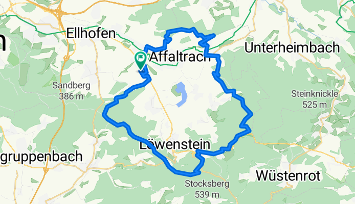
 Lehrensteinsfeld - Löwenstein
- Distance
- 25.4 km
- Ascent
- 434 m
- Descent
- 431 m
- Location
- Lehrensteinsfeld, Baden-Wurttemberg, Germany
 Nordwestl. Schwäbischer Wald
- Distance
- 100.2 km
- Ascent
- 1,572 m
- Descent
- 1,418 m
- Location
- Lehrensteinsfeld, Baden-Wurttemberg, Germany
 Breitenauer See
- Distance
- 19.8 km
- Ascent
- 335 m
- Descent
- 333 m
- Location
- Lehrensteinsfeld, Baden-Wurttemberg, Germany
 Affaltrach Lauffen a.N.
- Distance
- 25.4 km
- Ascent
- 292 m
- Descent
- 316 m
- Location
- Lehrensteinsfeld, Baden-Wurttemberg, Germany
 Runde durch Naturpark Fränkisch-Schwäbischer Wald
- Distance
- 91.5 km
- Ascent
- 963 m
- Descent
- 963 m
- Location
- Lehrensteinsfeld, Baden-Wurttemberg, Germany
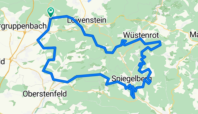
 Lehrensteinsfeld - Wüstenrot
- Distance
- 51.5 km
- Ascent
- 1,042 m
- Descent
- 1,083 m
- Location
- Lehrensteinsfeld, Baden-Wurttemberg, Germany
 Lehrensteinsfeld - Wüstenrot
- Distance
- 51.5 km
- Ascent
- 814 m
- Descent
- 814 m
- Location
- Lehrensteinsfeld, Baden-Wurttemberg, Germany
 Obersulm - Neippberg - Heilbronn - Obersulm
- Distance
- 69.3 km
- Ascent
- 708 m
- Descent
- 708 m
- Location
- Lehrensteinsfeld, Baden-Wurttemberg, Germany