
Cycling in Hartmannsdorf
Discover a map of 33 cycling routes and bike trails near Hartmannsdorf, created by our community.
Region portrait
Get to know Hartmannsdorf
Find the right bike route for you through Hartmannsdorf, where we've got 33 cycle routes to explore.
1,805 km
Tracked distance
33
Cycle routes
Community
Most active users in Hartmannsdorf


From our community
The best bike routes in and around Hartmannsdorf

Große Runde
Cycling route in Hartmannsdorf, Free State of Thuringia, Germany
Man kann von St,Gangloff starten. Im Uhrzeigersinn gefahren ist die Strecke am Anfang leichter. Strecke ist gemischt.Straße (wenig befahren),Waldwege und leichte Schotterstrecke. Landschaftlich sehr schön.
- 64.4 km
- Distance
- 549 m
- Ascent
- 549 m
- Descent

Tesseteiche, Käseschenke
Cycling route in Hartmannsdorf, Free State of Thuringia, Germany
von Töppeln bis Kraftsdorf auf Radweg/Straße
bei Kraftsdorf kurzer steiler Anstieg
restliche Strecke Feld/Waldweg
Kraftsdorf -> Tesseteiche -> Käseschenke -> Töppeln<br />
- 17.7 km
- Distance
- 194 m
- Ascent
- 194 m
- Descent

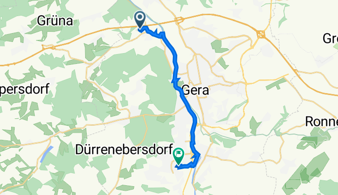
Rüdersdorf 75, Kraftsdorf nach Rüdersdorf 75, Kraftsdorf
Cycling route in Hartmannsdorf, Free State of Thuringia, Germany
- 69.9 km
- Distance
- 747 m
- Ascent
- 750 m
- Descent
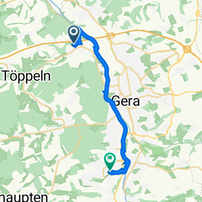
Erlbachweg 24, Gera nach Eichenstraße 20, Gera
Cycling route in Hartmannsdorf, Free State of Thuringia, Germany
- 10.3 km
- Distance
- 57 m
- Ascent
- 58 m
- Descent
Discover more routes
 5km Zeitfahr-Challenge TRV U11 & U13
- Distance
- 5 km
- Ascent
- 17 m
- Descent
- 15 m
- Location
- Hartmannsdorf, Free State of Thuringia, Germany
 Buga Lauf
- Distance
- 17 km
- Ascent
- 227 m
- Descent
- 176 m
- Location
- Hartmannsdorf, Free State of Thuringia, Germany
 Lutz-Runde Kaltenborn
- Distance
- 16.1 km
- Ascent
- 160 m
- Descent
- 160 m
- Location
- Hartmannsdorf, Free State of Thuringia, Germany
 Burgenroute
- Distance
- 75.5 km
- Ascent
- 518 m
- Descent
- 518 m
- Location
- Hartmannsdorf, Free State of Thuringia, Germany
 Am Erlbach 2, Kraftsdorf nach Kaltenborn 24, Kraftsdorf
- Distance
- 5 km
- Ascent
- 92 m
- Descent
- 16 m
- Location
- Hartmannsdorf, Free State of Thuringia, Germany
 Frankenthaler Straße 74, Gera nach Frankenthaler Straße 74, Gera
- Distance
- 48.9 km
- Ascent
- 504 m
- Descent
- 503 m
- Location
- Hartmannsdorf, Free State of Thuringia, Germany
 Erlbachweg 24, Gera nach Eichenstraße 22, Gera
- Distance
- 11.4 km
- Ascent
- 74 m
- Descent
- 61 m
- Location
- Hartmannsdorf, Free State of Thuringia, Germany
 Erlbachweg 24, Gera nach Eichenstraße 22, Gera
- Distance
- 10.6 km
- Ascent
- 36 m
- Descent
- 7 m
- Location
- Hartmannsdorf, Free State of Thuringia, Germany