
Cycling in Gräfelfing
Discover a map of 591 cycling routes and bike trails near Gräfelfing, created by our community.
Region portrait
Get to know Gräfelfing
Find the right bike route for you through Gräfelfing, where we've got 591 cycle routes to explore. Most people get on their bikes to ride here in the months of May and August.
19,148 km
Tracked distance
591
Cycle routes
12,978
Population
Community
Most active users in Gräfelfing

From our community
The best bike routes in and around Gräfelfing


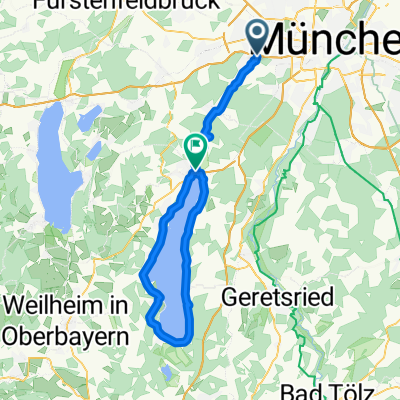
Germeringer See September 27 2020
Cycling route in Gräfelfing, Bavaria, Germany
- 30.6 km
- Distance
- 137 m
- Ascent
- 141 m
- Descent

Gräfelfing - Mittenwald - Mit Zug zurück
Cycling route in Gräfelfing, Bavaria, Germany
- 107.9 km
- Distance
- 566 m
- Ascent
- 198 m
- Descent

Am Vogelherd, Gräfelfing - Ammerland, Münsing
Cycling route in Gräfelfing, Bavaria, Germany
- 32.1 km
- Distance
- 318 m
- Ascent
- 262 m
- Descent

Trainingsstrecke (mittel) etwa 50 km
Cycling route in Gräfelfing, Bavaria, Germany
- 55.2 km
- Distance
- 204 m
- Ascent
- 204 m
- Descent
Discover more routes
 Von Gräfelfing bis Pasing
- Distance
- 4.3 km
- Ascent
- 0 m
- Descent
- 17 m
- Location
- Gräfelfing, Bavaria, Germany
 Starnberger
- Distance
- 69.3 km
- Ascent
- 239 m
- Descent
- 182 m
- Location
- Gräfelfing, Bavaria, Germany
 Mittag zwei
- Distance
- 33.9 km
- Ascent
- 203 m
- Descent
- 204 m
- Location
- Gräfelfing, Bavaria, Germany
 Hirschgarten Nymphenburg Teufelsberg
- Distance
- 25.1 km
- Ascent
- 65 m
- Descent
- 65 m
- Location
- Gräfelfing, Bavaria, Germany
 Gräfelfing zum Forsthaus Kasten
- Distance
- 6.5 km
- Ascent
- 51 m
- Descent
- 25 m
- Location
- Gräfelfing, Bavaria, Germany
 Mittagsrunde
- Distance
- 30 km
- Ascent
- 142 m
- Descent
- 140 m
- Location
- Gräfelfing, Bavaria, Germany
 Gräfelfing-Andechs-Herrsching
- Distance
- 36.8 km
- Ascent
- 259 m
- Descent
- 167 m
- Location
- Gräfelfing, Bavaria, Germany
 Lochham - Wörthsee
- Distance
- 24.3 km
- Ascent
- 0 m
- Descent
- 0 m
- Location
- Gräfelfing, Bavaria, Germany
Routes from Gräfelfing
Quick ride by bicycle from
Gräfelfing to Munich
Quick ride by bicycle from
Gräfelfing to Pasing
Routes to Gräfelfing
Quick ride by bicycle from
Munich to Gräfelfing
Quick ride by bicycle from
Neuried to Gräfelfing