
Cycling in Gesundbrunnen
Discover a map of 1,946 cycling routes and bike trails near Gesundbrunnen, created by our community.
Region portrait
Get to know Gesundbrunnen
Find the right bike route for you through Gesundbrunnen, where we've got 1,946 cycle routes to explore. Most people get on their bikes to ride here in the months of May and June.
75,402 km
Tracked distance
1,946
Cycle routes
84,789
Population
Community
Most active users in Gesundbrunnen


Handpicked routes
Discover Gesundbrunnen through these collections
Tour
From our community
The best bike routes in and around Gesundbrunnen
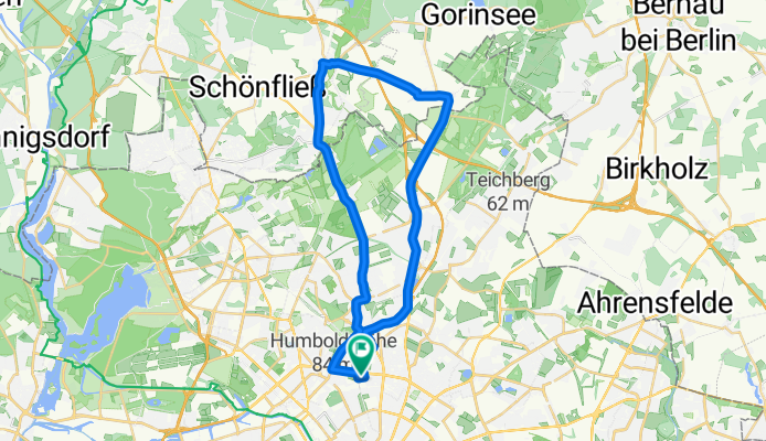
Prenzlauer Berg, Mühlenbeck, Blankenfelde
Cycling route in Gesundbrunnen, State of Berlin, Germany
- 33.8 km
- Distance
- 44 m
- Ascent
- 46 m
- Descent

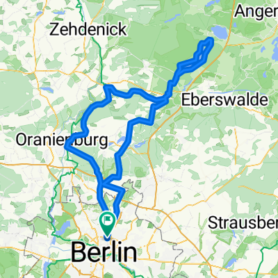
Die Eberswalde Extension 2
Cycling route in Gesundbrunnen, State of Berlin, Germany
- 119.3 km
- Distance
- 342 m
- Ascent
- 342 m
- Descent

Raus aus Berlin, anschlagen und zurück
Cycling route in Gesundbrunnen, State of Berlin, Germany
- 96.3 km
- Distance
- 393 m
- Ascent
- 403 m
- Descent
![[45km] Wedding-Schönerlinde-Basdorf-Mühlenbeck-Wedding](https://media.bikemap.net/routes/2272514/staticmaps/in_2477869c-b609-427b-9e20-7cb285ac7bb1_694x400_bikemap-2021-3D-static.png)
[45km] Wedding-Schönerlinde-Basdorf-Mühlenbeck-Wedding
Cycling route in Gesundbrunnen, State of Berlin, Germany
- 45.7 km
- Distance
- 85 m
- Ascent
- 85 m
- Descent
Discover more routes
 Feierabendrunde für den Norden
- Distance
- 67.1 km
- Ascent
- 61 m
- Descent
- 56 m
- Location
- Gesundbrunnen, State of Berlin, Germany
 Prenzlauer Berg <-> Wandlitz
- Distance
- 54.4 km
- Ascent
- 79 m
- Descent
- 79 m
- Location
- Gesundbrunnen, State of Berlin, Germany
 Training Nord 60 Lehnitz
- Distance
- 59.3 km
- Ascent
- 166 m
- Descent
- 162 m
- Location
- Gesundbrunnen, State of Berlin, Germany
 werbellinsee westanfahrt
- Distance
- 153.9 km
- Ascent
- 680 m
- Descent
- 680 m
- Location
- Gesundbrunnen, State of Berlin, Germany
 12 Strausberg Märkische Schweiz
- Distance
- 55.5 km
- Ascent
- 83 m
- Descent
- 83 m
- Location
- Gesundbrunnen, State of Berlin, Germany
 Rollmaterial
- Distance
- 113.6 km
- Ascent
- 455 m
- Descent
- 473 m
- Location
- Gesundbrunnen, State of Berlin, Germany
 Grunewald Runde von Mitte aus
- Distance
- 44.6 km
- Ascent
- 165 m
- Descent
- 158 m
- Location
- Gesundbrunnen, State of Berlin, Germany
 Teufelsberg Runde
- Distance
- 54 km
- Ascent
- 149 m
- Descent
- 146 m
- Location
- Gesundbrunnen, State of Berlin, Germany
Routes from Gesundbrunnen
By bicycle from
Gesundbrunnen to Friedrichshain
By bicycle from
Gesundbrunnen to Hansaviertel
Routes to Gesundbrunnen
By bicycle from
Tiergarten to Gesundbrunnen
By bicycle from
Wedding to Gesundbrunnen