
Cycling in Ville-sous-la-Ferté
Discover a map of 10 cycling routes and bike trails near Ville-sous-la-Ferté, created by our community.
Region portrait
Get to know Ville-sous-la-Ferté
Find the right bike route for you through Ville-sous-la-Ferté, where we've got 10 cycle routes to explore.
890 km
Tracked distance
10
Cycle routes
1,293
Population
Community
Most active users in Ville-sous-la-Ferté


From our community
The best bike routes in and around Ville-sous-la-Ferté

Camino 2015 6b Clairvaux nach Les Riceys
Cycling route in Ville-sous-la-Ferté, Grand Est, France
<table border="0" cellpadding="0" cellspacing="0" style="width:618px;" width="619">
<colgroup>
<col />
<col />
<col />
<col />
<col span="4" />
<col />
</colgroup>
<tbody>
<tr height="22">
<td height="22" style="height:22px;width:34px;">
3,0</td>
<td style="width:34px;">
3,0</td>
<td colspan="3" style="width:162px;">
(D12) Anstieg 120 hm</td>
<td style="width:64px;">
</td>
<td style="width:64px;">
</td>
<td style="width:64px;">
</td>
<td style="width:194px;">
</td>
</tr>
<tr height="22">
<td height="22" style="height:22px;width:34px;">
8,9</td>
<td style="width:34px;">
5,9</td>
<td colspan="7">
(D12) bis Champignol-lez-Mondeville Zentrum --> D70 (links)</td>
</tr>
<tr height="22">
<td height="22" style="height:22px;width:34px;">
9,2</td>
<td style="width:34px;">
0,3</td>
<td colspan="7">
am Ortsausgang: abknickende Vorfahrt nach rechts (D70)</td>
</tr>
<tr height="22">
<td height="22" style="height:22px;width:34px;">
15,7</td>
<td style="width:34px;">
6,5</td>
<td colspan="4">
Saint--Usage (links halten D70)</td>
<td>
</td>
<td>
</td>
<td>
</td>
</tr>
<tr height="22">
<td height="22" style="height:22px;width:34px;">
17,7</td>
<td style="width:34px;">
2,0</td>
<td colspan="3">
Fontette (D70)</td>
<td>
</td>
<td>
</td>
<td>
</td>
<td>
</td>
</tr>
<tr height="22">
<td height="22" style="height:22px;width:34px;">
22,0</td>
<td style="width:34px;">
4,3</td>
<td colspan="6">
Abbiege-Option vor Essoye (guter Schotterweg)</td>
<td>
</td>
</tr>
<tr height="22">
<td height="22" style="height:22px;width:34px;">
24,5</td>
<td style="width:34px;">
2,5</td>
<td colspan="4">
Essoyes (D67--> Loches)</td>
<td>
</td>
<td>
</td>
<td>
</td>
</tr>
<tr height="22">
<td height="22" style="height:22px;width:34px;">
27,5</td>
<td style="width:34px;">
3,0</td>
<td colspan="4">
Loches-sur-Ource (D145-->D67)</td>
<td>
</td>
<td>
</td>
<td>
</td>
</tr>
<tr height="22">
<td height="22" style="height:22px;width:34px;">
30,0</td>
<td style="width:34px;">
2,5</td>
<td colspan="2">
Londreville</td>
<td>
</td>
<td>
</td>
<td>
</td>
<td>
</td>
<td>
</td>
</tr>
<tr height="22">
<td height="22" style="height:22px;width:34px;">
35,1</td>
<td style="width:34px;">
5,1</td>
<td colspan="4">
Celles-sur-Ource (Brücke)</td>
<td>
</td>
<td>
</td>
<td>
</td>
</tr>
<tr height="22">
<td height="22" style="height:22px;width:34px;">
35,7</td>
<td style="width:34px;">
0,6</td>
<td colspan="7">
Abzweig nach Süden (gegenüber der Post: Rue de l'Église)</td>
</tr>
<tr height="22">
<td height="22" style="height:22px;width:34px;">
36,9</td>
<td style="width:34px;">
1,2</td>
<td colspan="7">
geradeaus in die Rue de Puits de Tour/Rue de Craies-->D671</td>
</tr>
<tr height="22">
<td height="22" style="height:22px;width:34px;">
37,2</td>
<td style="width:34px;">
0,3</td>
<td colspan="6">
--> hinter der Bahn D452 nach links Ri Polisy</td>
<td>
</td>
</tr>
<tr height="22">
<td height="22" style="height:22px;width:34px;">
42,0</td>
<td style="width:34px;">
4,8</td>
<td colspan="3">
Balnot-sur-Laignes</td>
<td>
</td>
<td>
</td>
<td>
</td>
<td>
</td>
</tr>
<tr height="21">
<td height="21" style="height:21px;width:34px;">
45,1</td>
<td style="width:34px;">
3,1</td>
<td colspan="3">
Ricey-Bas</td>
<td>
</td>
<td>
</td>
<td>
</td>
<td>
</td>
</tr>
</tbody>
</table>
Hotel Le Marius
2 Place De L'église<br />
10340 Les Riceys
Telefon +33325293165
- 45.2 km
- Distance
- 305 m
- Ascent
- 314 m
- Descent

De la Ferté à Rue Pierre Marasi 1, Laferté-sur-Aube
Cycling route in Ville-sous-la-Ferté, Grand Est, France
- 66.1 km
- Distance
- 662 m
- Ascent
- 655 m
- Descent

11 Ville-sous-la-Ferté - Étourvy Jakobsweg
Cycling route in Ville-sous-la-Ferté, Grand Est, France
- 64.9 km
- Distance
- 673 m
- Ascent
- 673 m
- Descent

0017 Longchamp sur Aujon to Paris
Cycling route in Ville-sous-la-Ferté, Grand Est, France
making my way
- 144.4 km
- Distance
- 437 m
- Ascent
- 570 m
- Descent
Discover more routes
 0016 past Troyes
- Distance
- 140.1 km
- Ascent
- 418 m
- Descent
- 559 m
- Location
- Ville-sous-la-Ferté, Grand Est, France
 Jakobsweg_8: Clairvaux - Etourvy
- Distance
- 66.3 km
- Ascent
- 846 m
- Descent
- 829 m
- Location
- Ville-sous-la-Ferté, Grand Est, France
 champignol nach Renzwiller
- Distance
- 281.6 km
- Ascent
- 2,483 m
- Descent
- 2,441 m
- Location
- Ville-sous-la-Ferté, Grand Est, France
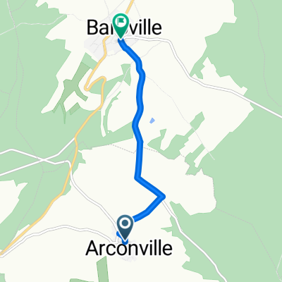 De Rue de l'Abreuvoir à Baroville - Place Mairie
- Distance
- 4.3 km
- Ascent
- 78 m
- Descent
- 141 m
- Location
- Ville-sous-la-Ferté, Grand Est, France
 De Rue du Seilley 5, Ville-sous-la-Ferté à Rue de la Maison Commune 1, Charrey-sur-Seine
- Distance
- 46.2 km
- Ascent
- 616 m
- Descent
- 629 m
- Location
- Ville-sous-la-Ferté, Grand Est, France
 De Route de Dijon 14, Ville-sous-la-Ferté à Rue du Moulin 3, Charrey-sur-Seine
- Distance
- 31.6 km
- Ascent
- 160 m
- Descent
- 169 m
- Location
- Ville-sous-la-Ferté, Grand Est, France