
Cycling in Villers-Cotterêts
Discover a map of 111 cycling routes and bike trails near Villers-Cotterêts, created by our community.
Region portrait
Get to know Villers-Cotterêts
Find the right bike route for you through Villers-Cotterêts, where we've got 111 cycle routes to explore. Most people get on their bikes to ride here in the months of June and July.
5,655 km
Tracked distance
111
Cycle routes
10,068
Population
Community
Most active users in Villers-Cotterêts


From our community
The best bike routes in and around Villers-Cotterêts

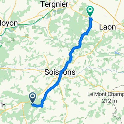
Rue de la Plaine, Fleury à Rue du Village, Fleury
Cycling route in Villers-Cotterêts, Hauts-de-France, France
- 45.1 km
- Distance
- 469 m
- Ascent
- 499 m
- Descent

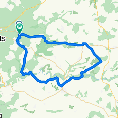
Chemin des Chevaux, Fleury à Rue de la Carpière, Fleury
Cycling route in Villers-Cotterêts, Hauts-de-France, France
- 39.3 km
- Distance
- 282 m
- Ascent
- 299 m
- Descent

Rue de la Plaine, Fleury à Rue de la Carpière, Fleury
Cycling route in Villers-Cotterêts, Hauts-de-France, France
- 45.9 km
- Distance
- 479 m
- Ascent
- 505 m
- Descent

Rue de la Plaine, Fleury à D 22, Oulchy-la-Ville
Cycling route in Villers-Cotterêts, Hauts-de-France, France
- 17.2 km
- Distance
- 82 m
- Ascent
- 89 m
- Descent
Discover more routes
 Chemin de Puisseux, Fleury à Rue Paul Dangenne, Crépy
- Distance
- 59.2 km
- Ascent
- 527 m
- Descent
- 567 m
- Location
- Villers-Cotterêts, Hauts-de-France, France
 Rue de la Plaine, Fleury à Chemin des Chevaux, Fleury
- Distance
- 44.7 km
- Ascent
- 486 m
- Descent
- 512 m
- Location
- Villers-Cotterêts, Hauts-de-France, France
 Nord de Retz
- Distance
- 37.7 km
- Ascent
- 336 m
- Descent
- 336 m
- Location
- Villers-Cotterêts, Hauts-de-France, France
 Avec Brice et Rémi
- Distance
- 78.1 km
- Ascent
- 637 m
- Descent
- 628 m
- Location
- Villers-Cotterêts, Hauts-de-France, France
 VillersCottêrets-Joigny TDF 2007
- Distance
- 196 km
- Ascent
- 895 m
- Descent
- 946 m
- Location
- Villers-Cotterêts, Hauts-de-France, France
 Montgobert - Saint-Pierre-Aigle - Longpont
- Distance
- 24.9 km
- Ascent
- 246 m
- Descent
- 246 m
- Location
- Villers-Cotterêts, Hauts-de-France, France
 De Unnamed Road, Coyolles à D81, Villers-Cotterêts
- Distance
- 1.5 km
- Ascent
- 32 m
- Descent
- 38 m
- Location
- Villers-Cotterêts, Hauts-de-France, France
 De 11 Rue de la Forêt, Montgobert à 11 Rue de la Forêt, Montgobert
- Distance
- 9.2 km
- Ascent
- 175 m
- Descent
- 174 m
- Location
- Villers-Cotterêts, Hauts-de-France, France