
Cycling in Sainte-Agnès
Discover a map of 34 cycling routes and bike trails near Sainte-Agnès, created by our community.
Region portrait
Get to know Sainte-Agnès
Find the right bike route for you through Sainte-Agnès, where we've got 34 cycle routes to explore.
1,723 km
Tracked distance
34
Cycle routes
1,141
Population
Community
Most active users in Sainte-Agnès


From our community
The best bike routes in and around Sainte-Agnès

Day 11: Saint-Antonin/Castillon - Col de Turini - Saint-Martin-Vesubie
Cycling route in Sainte-Agnès, Provence-Alpes-Côte d'Azur Region, France
- 57.9 km
- Distance
- 1,766 m
- Ascent
- 1,359 m
- Descent

Turini da Castillon
Cycling route in Sainte-Agnès, Provence-Alpes-Côte d'Azur Region, France
- 94.1 km
- Distance
- 3,310 m
- Ascent
- 3,311 m
- Descent

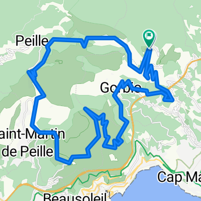
De 4275 Route de l'Armée des Alpes, Sainte-Agnès à 279 Chemin du Chiauso, Sainte-Agnès
Cycling route in Sainte-Agnès, Provence-Alpes-Côte d'Azur Region, France
- 50.9 km
- Distance
- 920 m
- Ascent
- 1,279 m
- Descent

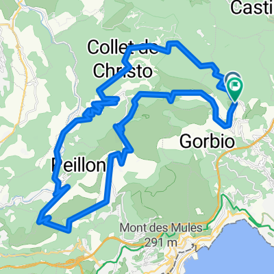
mentone
Cycling route in Sainte-Agnès, Provence-Alpes-Côte d'Azur Region, France
- 85.9 km
- Distance
- 1,448 m
- Ascent
- 1,448 m
- Descent
Discover more routes
 France Walks
- Distance
- 134.9 km
- Ascent
- 4,589 m
- Descent
- 4,531 m
- Location
- Sainte-Agnès, Provence-Alpes-Côte d'Azur Region, France
 SA Escarene Luceram Peira C Sospel Menton
- Distance
- 85.4 km
- Ascent
- 1,686 m
- Descent
- 2,330 m
- Location
- Sainte-Agnès, Provence-Alpes-Côte d'Azur Region, France
 tour Castillon
- Distance
- 63.2 km
- Ascent
- 1,575 m
- Descent
- 1,575 m
- Location
- Sainte-Agnès, Provence-Alpes-Côte d'Azur Region, France
 sospel 1
- Distance
- 36.4 km
- Ascent
- 948 m
- Descent
- 945 m
- Location
- Sainte-Agnès, Provence-Alpes-Côte d'Azur Region, France
 Monte 2022 SD
- Distance
- 2.3 km
- Ascent
- 271 m
- Descent
- 131 m
- Location
- Sainte-Agnès, Provence-Alpes-Côte d'Azur Region, France
 tur du bodon
- Distance
- 21.5 km
- Ascent
- 697 m
- Descent
- 710 m
- Location
- Sainte-Agnès, Provence-Alpes-Côte d'Azur Region, France
 Route du Colonel-des Banquettes, Sainte-Agnès to Route du Colonel-des Banquettes, Sainte-Agnès
- Distance
- 34.6 km
- Ascent
- 2,420 m
- Descent
- 2,421 m
- Location
- Sainte-Agnès, Provence-Alpes-Côte d'Azur Region, France
 Route du Colonel-des Banquettes, Sainte-Agnès to Route du Colonel-des Banquettes, Sainte-Agnès
- Distance
- 40.1 km
- Ascent
- 2,722 m
- Descent
- 2,725 m
- Location
- Sainte-Agnès, Provence-Alpes-Côte d'Azur Region, France