
Cycling in Saint-Chaffrey
Discover a map of 109 cycling routes and bike trails near Saint-Chaffrey, created by our community.
Region portrait
Get to know Saint-Chaffrey
Find the right bike route for you through Saint-Chaffrey, where we've got 109 cycle routes to explore. Most people get on their bikes to ride here in the months of July and August.
10,751 km
Tracked distance
109
Cycle routes
1,716
Population


From our community
The best bike routes in and around Saint-Chaffrey
CIRCUIT D ITALIE
Cycling route in Saint-Chaffrey, Provence-Alpes-Côte d'Azur Region, France
- 82.5 km
- Distance
- 1,326 m
- Ascent
- 1,325 m
- Descent

Cesana- Olux -Cesana
Cycling route in Saint-Chaffrey, Provence-Alpes-Côte d'Azur Region, France
- 64.2 km
- Distance
- 1,949 m
- Ascent
- 1,949 m
- Descent

Col de Galibier
Cycling route in Saint-Chaffrey, Provence-Alpes-Côte d'Azur Region, France
- 32 km
- Distance
- 1,326 m
- Ascent
- 16 m
- Descent

France, Alpes Nord 2 : Albertville - Col du Granon
Cycling route in Saint-Chaffrey, Provence-Alpes-Côte d'Azur Region, France
- 256.5 km
- Distance
- 4,489 m
- Ascent
- 6,491 m
- Descent
Discover more routes
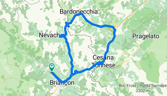
 Nevache - Pragelato
- Distance
- 51.1 km
- Ascent
- 1,155 m
- Descent
- 1,462 m
- Location
- Saint-Chaffrey, Provence-Alpes-Côte d'Azur Region, France
 Col de Granon
- Distance
- 26.6 km
- Ascent
- 1,104 m
- Descent
- 1,035 m
- Location
- Saint-Chaffrey, Provence-Alpes-Côte d'Azur Region, France
 JK Tour de France
- Distance
- 1,070 km
- Ascent
- 2,569 m
- Descent
- 3,917 m
- Location
- Saint-Chaffrey, Provence-Alpes-Côte d'Azur Region, France
 D6-SeyenAdventures-Graviflette2020-v7
- Distance
- 74.6 km
- Ascent
- 3,518 m
- Descent
- 3,829 m
- Location
- Saint-Chaffrey, Provence-Alpes-Côte d'Azur Region, France
 Lautaret, Croix de Fer, Telegraph, Galibier
- Distance
- 205.8 km
- Ascent
- 4,074 m
- Descent
- 4,071 m
- Location
- Saint-Chaffrey, Provence-Alpes-Côte d'Azur Region, France
 Etape 6c - Route grands Alpes
- Distance
- 6.4 km
- Ascent
- 22 m
- Descent
- 171 m
- Location
- Saint-Chaffrey, Provence-Alpes-Côte d'Azur Region, France
 4 Chantemerle - Modane
- Distance
- 77.7 km
- Ascent
- 2,254 m
- Descent
- 2,560 m
- Location
- Saint-Chaffrey, Provence-Alpes-Côte d'Azur Region, France
 Les 5 majeurs
- Distance
- 228.4 km
- Ascent
- 5,625 m
- Descent
- 5,623 m
- Location
- Saint-Chaffrey, Provence-Alpes-Côte d'Azur Region, France