
Cycling in Montmélian
Discover a map of 56 cycling routes and bike trails near Montmélian, created by our community.
Region portrait
Get to know Montmélian
Find the right bike route for you through Montmélian, where we've got 56 cycle routes to explore. Most people get on their bikes to ride here in the month of August.
4,168 km
Tracked distance
56
Cycle routes
4,291
Population


From our community
The best bike routes in and around Montmélian
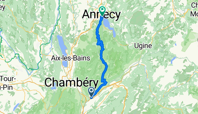
Rhone-Alpes: Etappe 6
Cycling route in Montmélian, Auvergne-Rhône-Alpes, France
Start: Montmélian
- Col du Frene
- Col de Leschaux
- Crêt de Châtillon
Ende: Annecy
- 79.2 km
- Distance
- 1,700 m
- Ascent
- 1,524 m
- Descent

VTT de MONTMELIAN à PONT ROYAL
Cycling route in Montmélian, Auvergne-Rhône-Alpes, France
11/06/2016 ***VTT BERGES ISERE ** bien [ facile ]
( RIVE GAUCHE * rectiligne* mais flaques d'eau importantes..)
MONTMELIAN _ PONT ISERE _PONT MORENS _PONT VICTOR EMMANUEL _PONT ROYAL
- 21.7 km
- Distance
- 85 m
- Ascent
- 84 m
- Descent

Momtélian - gières
Cycling route in Montmélian, Auvergne-Rhône-Alpes, France
joli!
Un A/R au col du coq rajoute 450m de D+
- 74.7 km
- Distance
- 1,335 m
- Ascent
- 1,193 m
- Descent

1988 - Tour de France - 04. Tag - Montmélian - Grenoble
Cycling route in Montmélian, Auvergne-Rhône-Alpes, France
- 70 km
- Distance
- 243 m
- Ascent
- 376 m
- Descent
Discover more routes
 2208_test_Bauges
- Distance
- 94 km
- Ascent
- 1,377 m
- Descent
- 1,364 m
- Location
- Montmélian, Auvergne-Rhône-Alpes, France
 Tour des Bauges
- Distance
- 147.5 km
- Ascent
- 1,872 m
- Descent
- 1,872 m
- Location
- Montmélian, Auvergne-Rhône-Alpes, France
 45 - Combe de Savoie
- Distance
- 29.3 km
- Ascent
- 371 m
- Descent
- 371 m
- Location
- Montmélian, Auvergne-Rhône-Alpes, France
 220805_j12_Arbin_StJeoire_colMarocaz_Cruet_Arbin
- Distance
- 35.4 km
- Ascent
- 872 m
- Descent
- 870 m
- Location
- Montmélian, Auvergne-Rhône-Alpes, France
 aix-le-bain1
- Distance
- 33.4 km
- Ascent
- 88 m
- Descent
- 136 m
- Location
- Montmélian, Auvergne-Rhône-Alpes, France
 traversée chartreuse
- Distance
- 83.8 km
- Ascent
- 1,942 m
- Descent
- 2,023 m
- Location
- Montmélian, Auvergne-Rhône-Alpes, France
 Col de Champ-Laurent
- Distance
- 62.8 km
- Ascent
- 1,259 m
- Descent
- 1,259 m
- Location
- Montmélian, Auvergne-Rhône-Alpes, France
 De 120 Route de Carmintran, Sainte-Hélène-du-Lac à 120 Route de Carmintran, Sainte-Hélène-du-Lac
- Distance
- 26.2 km
- Ascent
- 219 m
- Descent
- 219 m
- Location
- Montmélian, Auvergne-Rhône-Alpes, France