
Cycling in La Chapelle-de-Guinchay
Discover a map of 15 cycling routes and bike trails near La Chapelle-de-Guinchay, created by our community.
Region portrait
Get to know La Chapelle-de-Guinchay
Find the right bike route for you through La Chapelle-de-Guinchay, where we've got 15 cycle routes to explore.
1,058 km
Tracked distance
15
Cycle routes
2,626
Population
Community
Most active users in La Chapelle-de-Guinchay


From our community
The best bike routes in and around La Chapelle-de-Guinchay

Loop into Ain, back via Thoissey
Cycling route in La Chapelle-de-Guinchay, Bourgogne-Franche-Comté, France
- 43.6 km
- Distance
- 195 m
- Ascent
- 225 m
- Descent

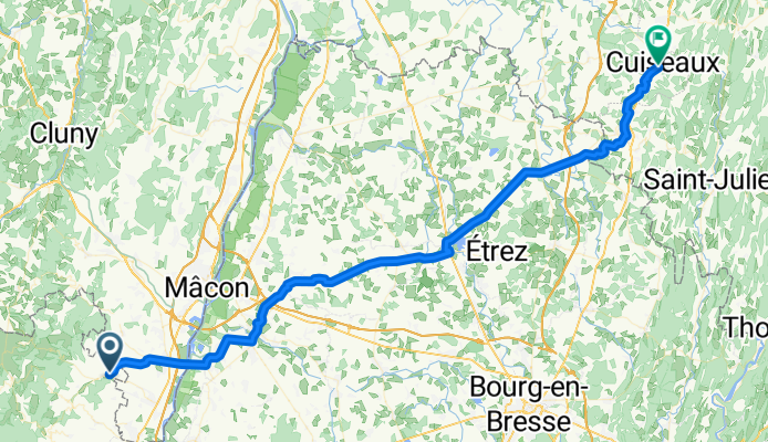
Macon Süd - Genf
Cycling route in La Chapelle-de-Guinchay, Bourgogne-Franche-Comté, France
- 311.4 km
- Distance
- 575 m
- Ascent
- 370 m
- Descent
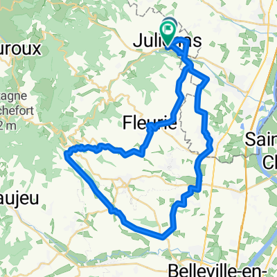
Juliénas -Cuiseaux
Cycling route in La Chapelle-de-Guinchay, Bourgogne-Franche-Comté, France
- 71.8 km
- Distance
- 336 m
- Ascent
- 327 m
- Descent

circuit 1
Cycling route in La Chapelle-de-Guinchay, Bourgogne-Franche-Comté, France
- 58 km
- Distance
- 1,271 m
- Ascent
- 1,271 m
- Descent
Discover more routes
 Veloreisli 2021_2
- Distance
- 78 km
- Ascent
- 1,514 m
- Descent
- 1,517 m
- Location
- La Chapelle-de-Guinchay, Bourgogne-Franche-Comté, France
 loz-st syphrin
- Distance
- 201 km
- Ascent
- 1,920 m
- Descent
- 1,557 m
- Location
- La Chapelle-de-Guinchay, Bourgogne-Franche-Comté, France
 1 Impasse des Petits Bois, La Chapelle-de-Guinchay à 29 Rue Lamartine, Cluny
- Distance
- 31.2 km
- Ascent
- 290 m
- Descent
- 250 m
- Location
- La Chapelle-de-Guinchay, Bourgogne-Franche-Comté, France
 Julienas 2
- Distance
- 57.1 km
- Ascent
- 537 m
- Descent
- 536 m
- Location
- La Chapelle-de-Guinchay, Bourgogne-Franche-Comté, France
 Out to Pizay, Truges, back via Chiroubles and Fleurie
- Distance
- 39.9 km
- Ascent
- 703 m
- Descent
- 718 m
- Location
- La Chapelle-de-Guinchay, Bourgogne-Franche-Comté, France
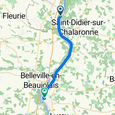 Saint-Didier-sur-Chalaronne to Chemin Vert, Montmerle-sur-Saône
- Distance
- 14.4 km
- Ascent
- 23 m
- Descent
- 3 m
- Location
- La Chapelle-de-Guinchay, Bourgogne-Franche-Comté, France
 De D17E 2080, Saint-Amour-Bellevue à Champ de la Lié 746, Varennes-lès-Mâcon
- Distance
- 8.1 km
- Ascent
- 91 m
- Descent
- 198 m
- Location
- La Chapelle-de-Guinchay, Bourgogne-Franche-Comté, France
 hbjjhh
- Distance
- 30 km
- Ascent
- 562 m
- Descent
- 436 m
- Location
- La Chapelle-de-Guinchay, Bourgogne-Franche-Comté, France