
Cycling in Chatuzange-le-Goubet
Discover a map of 70 cycling routes and bike trails near Chatuzange-le-Goubet, created by our community.
Region portrait
Get to know Chatuzange-le-Goubet
Find the right bike route for you through Chatuzange-le-Goubet, where we've got 70 cycle routes to explore. Most people get on their bikes to ride here in the months of July and August.
6,810 km
Tracked distance
70
Cycle routes
4,278
Population
Community
Most active users in Chatuzange-le-Goubet


From our community
The best bike routes in and around Chatuzange-le-Goubet

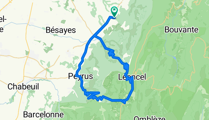
Léoncel-La Chapelle en Vercors
Cycling route in Chatuzange-le-Goubet, Auvergne-Rhône-Alpes, France
- 48.5 km
- Distance
- 1,048 m
- Ascent
- 1,104 m
- Descent

Col des Limouches en Col de Tourniol
Cycling route in Chatuzange-le-Goubet, Auvergne-Rhône-Alpes, France
- 47.6 km
- Distance
- 1,019 m
- Ascent
- 1,020 m
- Descent

Koninginnerit
Cycling route in Chatuzange-le-Goubet, Auvergne-Rhône-Alpes, France
- 84.7 km
- Distance
- 2,203 m
- Ascent
- 2,209 m
- Descent
Col des Limouches & Col de Tourniol
Cycling route in Chatuzange-le-Goubet, Auvergne-Rhône-Alpes, France
- 47.1 km
- Distance
- 970 m
- Ascent
- 970 m
- Descent
Discover more routes
 Combe d´Oyans - Romans sur Isère
- Distance
- 53.8 km
- Ascent
- 388 m
- Descent
- 387 m
- Location
- Chatuzange-le-Goubet, Auvergne-Rhône-Alpes, France
 Vercors
- Distance
- 69.6 km
- Ascent
- 1,484 m
- Descent
- 1,484 m
- Location
- Chatuzange-le-Goubet, Auvergne-Rhône-Alpes, France
 Col de Tourniol op, Col des Limouches af
- Distance
- 46.8 km
- Ascent
- 1,048 m
- Descent
- 1,048 m
- Location
- Chatuzange-le-Goubet, Auvergne-Rhône-Alpes, France
 col des limouches op, col de tourniol af
- Distance
- 46.1 km
- Ascent
- 997 m
- Descent
- 997 m
- Location
- Chatuzange-le-Goubet, Auvergne-Rhône-Alpes, France
 Barbières a col Tourniol
- Distance
- 35.5 km
- Ascent
- 933 m
- Descent
- 930 m
- Location
- Chatuzange-le-Goubet, Auvergne-Rhône-Alpes, France
 Leoncel- Col de la Bataille- Col du Rousset- Grand Goulets- Petit Goulets
- Distance
- 90.5 km
- Ascent
- 1,264 m
- Descent
- 1,944 m
- Location
- Chatuzange-le-Goubet, Auvergne-Rhône-Alpes, France
 TOURNIOL, por Barbières
- Distance
- 12.2 km
- Ascent
- 807 m
- Descent
- 45 m
- Location
- Chatuzange-le-Goubet, Auvergne-Rhône-Alpes, France
 les picards,peyrus ,rond point,montelier 2é partie)
- Distance
- 21.8 km
- Ascent
- 111 m
- Descent
- 338 m
- Location
- Chatuzange-le-Goubet, Auvergne-Rhône-Alpes, France