
Cycling in Challes-les-Eaux
Discover a map of 74 cycling routes and bike trails near Challes-les-Eaux, created by our community.
Region portrait
Get to know Challes-les-Eaux
Find the right bike route for you through Challes-les-Eaux, where we've got 74 cycle routes to explore. Most people get on their bikes to ride here in the months of March and August.
4,876 km
Tracked distance
74
Cycle routes
4,436
Population
Community
Most active users in Challes-les-Eaux


From our community
The best bike routes in and around Challes-les-Eaux

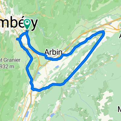
From Challes-les-Eaux to Porte-de-Savoie
Cycling route in Challes-les-Eaux, Auvergne-Rhône-Alpes, France
- 9.4 km
- Distance
- 94 m
- Ascent
- 74 m
- Descent

Alpes Chambéry / Il était une fois une jolie balade au Pays des Bauges (Frêne - Lindar - Prés) ... qui s'est terminée sous l'orage !
Cycling route in Challes-les-Eaux, Auvergne-Rhône-Alpes, France
- 89 km
- Distance
- 1,699 m
- Ascent
- 1,699 m
- Descent

TT PLAINPALAIS
Cycling route in Challes-les-Eaux, Auvergne-Rhône-Alpes, France
This Circuit of the Grand Massif makes a welcome
return in 2011. Some fantastic alpine scenery on this lovely ride.
- 61.3 km
- Distance
- 1,418 m
- Ascent
- 1,418 m
- Descent

From Challes-les-Eaux to Porte-de-Savoie
Cycling route in Challes-les-Eaux, Auvergne-Rhône-Alpes, France
- 9.4 km
- Distance
- 94 m
- Ascent
- 74 m
- Descent
Discover more routes
 La féclaz
- Distance
- 60.5 km
- Ascent
- 1,306 m
- Descent
- 1,301 m
- Location
- Challes-les-Eaux, Auvergne-Rhône-Alpes, France
 TT ST MICHAELS MT
- Distance
- 16.5 km
- Ascent
- 437 m
- Descent
- 445 m
- Location
- Challes-les-Eaux, Auvergne-Rhône-Alpes, France
 Test Revard pour le raid Genève Venise
- Distance
- 82.2 km
- Ascent
- 1,493 m
- Descent
- 1,500 m
- Location
- Challes-les-Eaux, Auvergne-Rhône-Alpes, France
 challes - col de Marocaz
- Distance
- 41.8 km
- Ascent
- 799 m
- Descent
- 800 m
- Location
- Challes-les-Eaux, Auvergne-Rhône-Alpes, France
 TT ISIERE
- Distance
- 64.6 km
- Ascent
- 395 m
- Descent
- 395 m
- Location
- Challes-les-Eaux, Auvergne-Rhône-Alpes, France
 TT COL DU MAROCAZ
- Distance
- 39.8 km
- Ascent
- 818 m
- Descent
- 818 m
- Location
- Challes-les-Eaux, Auvergne-Rhône-Alpes, France
 Chapelle du Mont St Michel - Massif des Bauges
- Distance
- 12.4 km
- Ascent
- 717 m
- Descent
- 717 m
- Location
- Challes-les-Eaux, Auvergne-Rhône-Alpes, France
 TT Col du Granier, Corbel, Chambery
- Distance
- 64.5 km
- Ascent
- 1,372 m
- Descent
- 1,372 m
- Location
- Challes-les-Eaux, Auvergne-Rhône-Alpes, France