
Cycling in Cattenom
Discover a map of 44 cycling routes and bike trails near Cattenom, created by our community.
Region portrait
Get to know Cattenom
Find the right bike route for you through Cattenom, where we've got 44 cycle routes to explore.
1,393 km
Tracked distance
44
Cycle routes
2,417
Population
Community
Most active users in Cattenom


From our community
The best bike routes in and around Cattenom

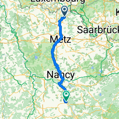
Day 3: CattenomSainte-Ruffine
Cycling route in Cattenom, Grand Est, France
Cattenom, Thionville, Uckange, Metz, Sainte-Ruffine via La Voie Bleue
Overnight at La Maison Ruffinoise 4 Grand rue, 57130 Sainte-Ruffine, France
- 51.9 km
- Distance
- 378 m
- Ascent
- 169 m
- Descent

Quick ride through Cattenom
Cycling route in Cattenom, Grand Est, France
- 9.7 km
- Distance
- 14 m
- Ascent
- 16 m
- Descent

De Rue Principale, Puttelange-lès-Thionville à Rue Principale, Puttelange-lès-Thionville
Cycling route in Cattenom, Grand Est, France
- 32.8 km
- Distance
- 424 m
- Ascent
- 428 m
- Descent

19bis Boucle d'Alsace-Lorraine, Cattenom à 136 Les Basses Terres, Manom
Cycling route in Cattenom, Grand Est, France
- 11.2 km
- Distance
- 0 m
- Ascent
- 10 m
- Descent
Discover more routes
 DE BOUST A DUDELANGE
- Distance
- 51.8 km
- Ascent
- 328 m
- Descent
- 327 m
- Location
- Cattenom, Grand Est, France
 11–15 Rue des Vignes, Fixem à 56 Rue des Joncs, Beyren-lès-Sierck
- Distance
- 6.2 km
- Ascent
- 98 m
- Descent
- 83 m
- Location
- Cattenom, Grand Est, France
 Itinéraire modéré en Thionville
- Distance
- 13.9 km
- Ascent
- 0 m
- Descent
- 53 m
- Location
- Cattenom, Grand Est, France
 charles le temeraire
- Distance
- 157.4 km
- Ascent
- 157 m
- Descent
- 44 m
- Location
- Cattenom, Grand Est, France
 Tour Boler-Lux.-Rodemack
- Distance
- 21.9 km
- Ascent
- 209 m
- Descent
- 206 m
- Location
- Cattenom, Grand Est, France
 Rodemack
- Distance
- 41.4 km
- Ascent
- 281 m
- Descent
- 306 m
- Location
- Cattenom, Grand Est, France
 De Rue Principale, Puttelange-lès-Thionville à Allée du Bois, Mondorff
- Distance
- 43.3 km
- Ascent
- 496 m
- Descent
- 492 m
- Location
- Cattenom, Grand Est, France
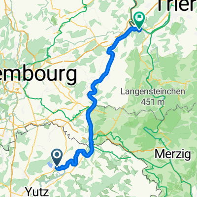 Von Cattenom bis Wasserliesch
- Distance
- 55.8 km
- Ascent
- 372 m
- Descent
- 355 m
- Location
- Cattenom, Grand Est, France