
Cycling in Aspet
Discover a map of 215 cycling routes and bike trails near Aspet, created by our community.
Region portrait
Get to know Aspet
Find the right bike route for you through Aspet, where we've got 215 cycle routes to explore. Most people get on their bikes to ride here in the months of June and July.
18,831 km
Tracked distance
215
Cycle routes
1,154
Population
From our community
The best bike routes in and around Aspet
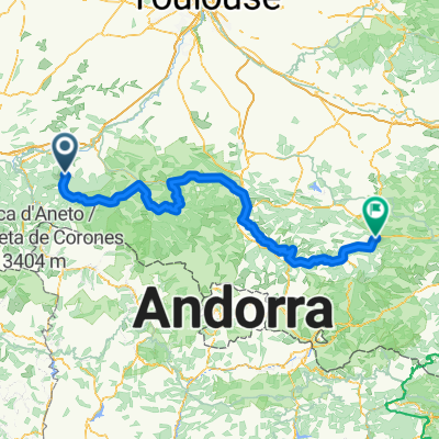
Ride Day 14—24 Sept 2005—09800 Saint-Lary to 09000 Col des Marrous – Le Bosc – Foix
Cycling route in Aspet, Languedoc-Roussillon-Midi-Pyrénées, France
<span style="font-size: 12pt; font-family: Arial;">Today’s ride, which had
plenty of solid climbing, was entirely within the Parc Naturel Régional des
Pyrénées Ariégeoises.</span> <span style="font-size: 12pt; font-family: Arial;"><span> </span>Starting from
Saint Lary at 692 M, we descended to St Girons at about 400 M.<span> </span>From there we climbed through various
cols to 1465 M and then descended to our stopping point for the evening at 990
M.<span> </span>Along the way, we passed
through the following cols:</span>
<span style="font-size: 12pt; font-family: Arial;">Col de Crouzette at 1241 M</span>
<span style="font-size: 12pt; font-family: Arial;">Col
du Portel at 1465 M</span>
<span style="font-size: 12pt; font-family: Arial;">Col de Péguère at 1375 M</span>
<span style="font-size: 12pt; font-family: Arial;">Col de Jouels at 1247 M</span>
<span style="font-size: 12pt; font-family: Arial;">Col de
Marrous at 990 M</span>
<span style="font-size: 12pt; font-family: Arial;">Going from west to east
gave us some very steep climbing up to the first col.<span> </span>Four years previously in 2001, we did this same climb but
east to west…and the slopes for the bulk of the climb along D17 from Foix were
a lot gentler.</span>
<span style="font-size: 12pt; font-family: Arial;">D18 was a very narrow road
with the steepest climbing and fortunately only six cars passed by while we
were struggling up…and that was six cars too many.<span> </span>Lower down the climb when we’d been on D3 before we got near
Rivèrenet on D33, there had been a steady stream of cars that had us a bit
worried.</span>
<span style="font-size: 12pt; font-family: Arial;">During the climb and
especially between the first three cols, the views were spectacular.<span> </span>It felt like being on top of the
world.<span> </span>I recall that four years
ago when we arrived at the Col de Péguère and the orientation table that’s
there, it was foggy and we couldn’t see any of the view.</span>
Background:<br /><br /><br />My wife and I have been doing self-supported tours in Western Europe (a majority in France) since 1993. This series of rides covers our 2005 2 month route through parts of France. Our beginning and ending point is near Chaduri (south of Angoulême) where our friends have a farm with Gites and Chambres d'Hotes.<br /><br /><br />We rode our Dawes touring bicycles purchased in 1993 heavily loaded with 700Cx32 tires. All of our riding was on paved roads, mostly with very little traffic.<br /><br /><br />If any questions, feel free to email me at jeffkadet@netdiving.com<br /><br /><br />Jeff
- 62.7 km
- Distance
- 1,118 m
- Ascent
- 809 m
- Descent
2012 T5
Cycling route in Aspet, Languedoc-Roussillon-Midi-Pyrénées, France
<span class="location">Saint-Lary / Midi-Pyrénées / France<span> </span></span>
- 113.1 km
- Distance
- 1,101 m
- Ascent
- 1,104 m
- Descent
TDP - ETAPE 9
Cycling route in Aspet, Languedoc-Roussillon-Midi-Pyrénées, France
- 80.3 km
- Distance
- 1,541 m
- Ascent
- 1,786 m
- Descent
Laruns - Aspet
Cycling route in Aspet, Languedoc-Roussillon-Midi-Pyrénées, France
- 236.8 km
- Distance
- 5,656 m
- Ascent
- 5,580 m
- Descent
Discover more routes
- MAUNA KEA
- Distance
- 401.5 km
- Ascent
- 7,019 m
- Descent
- 7,012 m
- Location
- Aspet, Languedoc-Roussillon-Midi-Pyrénées, France
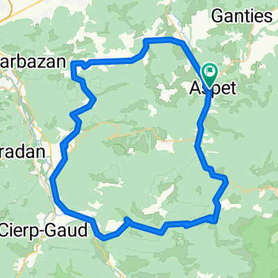
- Circuit n° 1 :St Béat/Balès/Portillon/St Béat 93Km
- Distance
- 93 km
- Ascent
- 2,939 m
- Descent
- 2,600 m
- Location
- Aspet, Languedoc-Roussillon-Midi-Pyrénées, France
- AAA Pyrenäen 5
- Distance
- 100 km
- Ascent
- 2,476 m
- Descent
- 2,343 m
- Location
- Aspet, Languedoc-Roussillon-Midi-Pyrénées, France
- CATFR_2022_Tag3_StLary_PortetDAspet_Vielha
- Distance
- 60.6 km
- Ascent
- 1,862 m
- Descent
- 1,577 m
- Location
- Aspet, Languedoc-Roussillon-Midi-Pyrénées, France
- Pyrenäen Tag 5: Saint Lary nach Tarascon
- Distance
- 111.8 km
- Ascent
- 2,427 m
- Descent
- 2,647 m
- Location
- Aspet, Languedoc-Roussillon-Midi-Pyrénées, France
- Fr2022 11_Chaum-La Vella
- Distance
- 146.8 km
- Ascent
- 4,141 m
- Descent
- 3,614 m
- Location
- Aspet, Languedoc-Roussillon-Midi-Pyrénées, France
- Fronsac - Bielle
- Distance
- 209.3 km
- Ascent
- 5,029 m
- Descent
- 5,058 m
- Location
- Aspet, Languedoc-Roussillon-Midi-Pyrénées, France
- Tp1 chaum-seix
- Distance
- 82.3 km
- Ascent
- 1,871 m
- Descent
- 1,836 m
- Location
- Aspet, Languedoc-Roussillon-Midi-Pyrénées, France