
Cycling in Aix-en-Othe
Discover a map of 23 cycling routes and bike trails near Aix-en-Othe, created by our community.
Region portrait
Get to know Aix-en-Othe
Find the right bike route for you through Aix-en-Othe, where we've got 23 cycle routes to explore.
1,321 km
Tracked distance
23
Cycle routes
2,167
Population
Community
Most active users in Aix-en-Othe


From our community
The best bike routes in and around Aix-en-Othe

E3 Aix en Othe - Dienville
Cycling route in Aix-en-Othe, Grand Est, France
- 89.3 km
- Distance
- 339 m
- Ascent
- 338 m
- Descent

26 Rue de St-Rémeau, Aix-Villemaur-Pâlis nach 22 Rue de St-Rémeau, Aix-Villemaur-Pâlis
Cycling route in Aix-en-Othe, Grand Est, France
- 9.8 km
- Distance
- 162 m
- Ascent
- 161 m
- Descent

Route du cidre partie 1
Cycling route in Aix-en-Othe, Grand Est, France
- 56.7 km
- Distance
- 522 m
- Ascent
- 524 m
- Descent
Discover more routes
 13/ Stawy za Villemaur sur.. - Sens camp. municypalny
- Distance
- 38 km
- Ascent
- 69 m
- Descent
- 112 m
- Location
- Aix-en-Othe, Grand Est, France
 sen ver
- Distance
- 232.9 km
- Ascent
- 541 m
- Descent
- 452 m
- Location
- Aix-en-Othe, Grand Est, France
 24 Rue de St-Rémeau, Aix-Villemaur-Pâlis nach 18 Rue de St-Rémeau, Aix-Villemaur-Pâlis
- Distance
- 11.9 km
- Ascent
- 140 m
- Descent
- 141 m
- Location
- Aix-en-Othe, Grand Est, France
 7. Etappe: Villneuve l'Archevêque - Cannes-Ecluse
- Distance
- 54.5 km
- Ascent
- 190 m
- Descent
- 245 m
- Location
- Aix-en-Othe, Grand Est, France
 sens verdun
- Distance
- 233 km
- Ascent
- 543 m
- Descent
- 442 m
- Location
- Aix-en-Othe, Grand Est, France
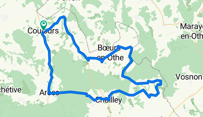
 Rue Bob Carrière, Bœurs-en-Othe à Rue Bob Carrière, Bœurs-en-Othe
- Distance
- 12.2 km
- Ascent
- 156 m
- Descent
- 154 m
- Location
- Aix-en-Othe, Grand Est, France
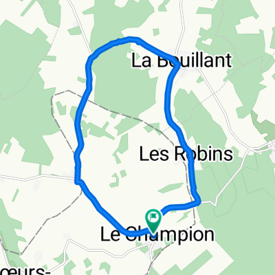
 Gipfeli 2
- Distance
- 11.8 km
- Ascent
- 145 m
- Descent
- 146 m
- Location
- Aix-en-Othe, Grand Est, France
 1 Chemin de Rigny, Paisy-Cosdon nach 3 Chemin de Rigny, Paisy-Cosdon
- Distance
- 64 km
- Ascent
- 1,055 m
- Descent
- 1,064 m
- Location
- Aix-en-Othe, Grand Est, France