
Cycling in Curanilahue
Discover a map of 42 cycling routes and bike trails near Curanilahue, created by our community.
Region portrait
Get to know Curanilahue
Find the right bike route for you through Curanilahue, where we've got 42 cycle routes to explore. Most people get on their bikes to ride here in the month of February.
771 km
Tracked distance
42
Cycle routes
30,611
Population
Community
Most active users in Curanilahue


From our community
The best bike routes in and around Curanilahue

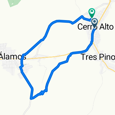
Paseo rápido en Los Álamos
Cycling route in Curanilahue, Región del Biobío, Chile
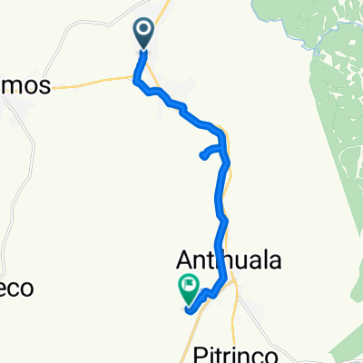
- 17 km
- Distance
- 376 m
- Ascent
- 378 m
- Descent

Ruta desde Cruce Calle Caupolicán (Curanilahue) - Mundo Nuevo - Cruce O-940 (Los Cruceros), Curanilahue
Cycling route in Curanilahue, Región del Biobío, Chile
- 12.5 km
- Distance
- 156 m
- Ascent
- 228 m
- Descent

Maitén, Curanilahue a Ramón Freire 1327, Curanilahue
Cycling route in Curanilahue, Región del Biobío, Chile
- 1.4 km
- Distance
- 28 m
- Ascent
- 22 m
- Descent

Arturo Prat 775, Curanilahue a Avenida Vicuña Mackenna 1522, Concepción
Cycling route in Curanilahue, Región del Biobío, Chile
- 113.3 km
- Distance
- 886 m
- Ascent
- 1,008 m
- Descent
Discover more routes
 El frutillar, Curanilahue a Los copihues, Curanilahue
- Distance
- 8 km
- Ascent
- 196 m
- Descent
- 189 m
- Location
- Curanilahue, Región del Biobío, Chile
 Ruta moderata
- Distance
- 10.8 km
- Ascent
- 150 m
- Descent
- 189 m
- Location
- Curanilahue, Región del Biobío, Chile
 Ruta de descanso
- Distance
- 12.5 km
- Ascent
- 114 m
- Descent
- 121 m
- Location
- Curanilahue, Región del Biobío, Chile
 a ver a mi amorcito
- Distance
- 23.4 km
- Ascent
- 359 m
- Descent
- 322 m
- Location
- Curanilahue, Región del Biobío, Chile
 De Tucapel 340, Curanilahue a Janequeo 859, Curanilahue
- Distance
- 2.2 km
- Ascent
- 55 m
- Descent
- 55 m
- Location
- Curanilahue, Región del Biobío, Chile
 Ruta herrera vateas
- Distance
- 6.9 km
- Ascent
- 119 m
- Descent
- 152 m
- Location
- Curanilahue, Región del Biobío, Chile
 Colico Sur, Curanilahue a El frutillar, Curanilahue
- Distance
- 4.2 km
- Ascent
- 157 m
- Descent
- 158 m
- Location
- Curanilahue, Región del Biobío, Chile
 Ruta relajada en cañete
- Distance
- 20.5 km
- Ascent
- 0 m
- Descent
- 0 m
- Location
- Curanilahue, Región del Biobío, Chile