
Cycling in Mexico
Discover a map of 50,749 cycling routes and bike trails in Mexico, created by our community.
Region portrait
Get to know Mexico
Find and create the best bike routes through Mexico with the help of the bike route planner which will lead you to beautiful beaches, tasty food and rich history. The landscape is mainly characterised by high mountains and deep gorges in the centre, deserts in the North and dense rain forests in the South and East. An exotic flora and fauna is omnipresent in the country’s tropical rain forests and national parks.
2,215,142 km
Tracked distance
50,749
Cycle routes
112.5 million
Population
Community
Most active users in Mexico


Handpicked routes
Discover Mexico through these collections
- Tour
 Tour
Tour


From our community
The best bike routes in Mexico


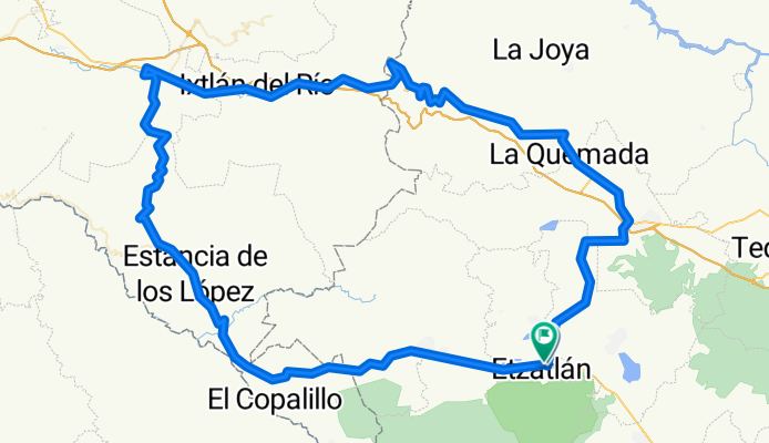
Tequila bike | Circuito del Abuelo
Cycling route in Etzatlán, Jalisco, Mexico
- 182.3 km
- Distance
- 2,701 m
- Ascent
- 2,702 m
- Descent


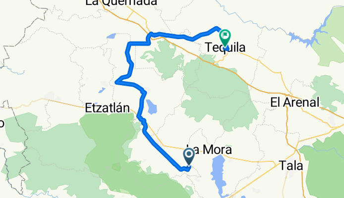
Tequila bike | Tequila
Cycling route in Teuchitlán, Jalisco, Mexico
- 71.6 km
- Distance
- 342 m
- Ascent
- 432 m
- Descent


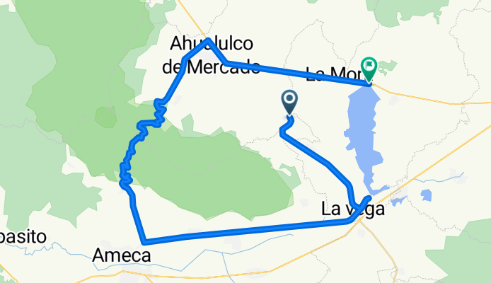
Tequila bike | Vías Verdes 2
Cycling route in Teuchitlán, Jalisco, Mexico
- 75.4 km
- Distance
- 653 m
- Ascent
- 665 m
- Descent


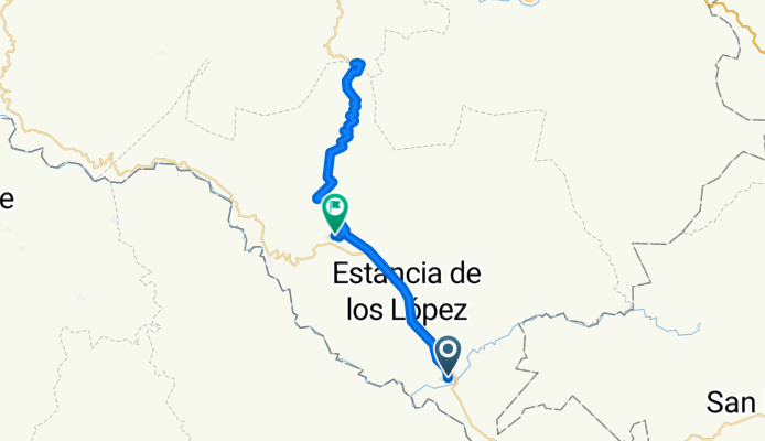
Tequila bike | Barranca del Oro
Cycling route in Amatlán de Cañas, Nayarit, Mexico
- 50.3 km
- Distance
- 1,249 m
- Ascent
- 1,249 m
- Descent
Discover more routes
 Tequila bike | San Marcos
- Distance
- 72.8 km
- Ascent
- 640 m
- Descent
- 552 m
- Location
- Teuchitlán, Jalisco, Mexico
 Tequila bike | Etzatlán
- Distance
- 90.4 km
- Ascent
- 558 m
- Descent
- 559 m
- Location
- Tequila, Jalisco, Mexico
 Tequila bike | Hidroelectrica La Yesca
- Distance
- 52 km
- Ascent
- 1,333 m
- Descent
- 1,335 m
- Location
- Hostotipaquillo, Jalisco, Mexico
 rumbo a la presa
- Distance
- 12.6 km
- Ascent
- 78 m
- Descent
- 80 m
- Location
- Hermosillo, Sonora, Mexico
 De Cerrada del Sol a Cerrada del Sol
- Distance
- 19.1 km
- Ascent
- 93 m
- Descent
- 72 m
- Location
- Los Reyes Acozac, Morelos, Mexico
 De Cerrada del Sol a Cerrada del Sol
- Distance
- 34.6 km
- Ascent
- 174 m
- Descent
- 173 m
- Location
- Los Reyes Acozac, Morelos, Mexico
 caña hueca ruta 1
- Distance
- 6 km
- Ascent
- 255 m
- Descent
- 235 m
- Location
- Tuxtla Gutiérrez, Chiapas, Mexico
 De Calle Reyes Zumpango & Calle Santa Isabel a Cerrada del Sol
- Distance
- 22.1 km
- Ascent
- 106 m
- Descent
- 99 m
- Location
- Los Reyes Acozac, Morelos, Mexico
Highlights
- On the Yucatán peninsula, there are ancient maya ruins as well as the beach resorts of Tulum and Cancun. The fascinating Yucatán in southern Mexico is best explored by bike, whether on less frequented side streets or on bike tours through the tropical rain forest.
- Guadalajara, the capital of the state Jalisco, offers an unique mix of colonial and indigenous tapatíos influences. The city is known for its wide streets, idyllic parks and old buildings with European influences. Moreover, mariachi and tequila were invented in this city. So get on your bike and discover the city.
- The convent route (in the states Morelos & Puebla) leads through Mexico’s historically most valuable regions. The places where the first convents were founded during the colonial period lie between 1600 and 2000 metres in Mexico’s temperate climate zone and thus offer ideal conditions for biking.
Tips
- A bigger selection of spare parts is only available in big cities such as Cancun. Smaller bike shops usually only offer spare parts of lesser quality.
- The climate in the North is desert-like, you can expect snow and frost in winter in the highlands, the South is tropical with hurricane season lasting from June until November.
- Who bikes, must also eat, eat, eat! The Mexican cuisine is fantastic and very diverse.
See where people are biking in Mexico
Popular cycling regions in Mexico

