
Cycling in Brooklyn Heights
Discover a map of 28 cycling routes and bike trails near Brooklyn Heights, created by our community.
Region portrait
Get to know Brooklyn Heights
Find the right bike route for you through Brooklyn Heights, where we've got 28 cycle routes to explore.
275 km
Tracked distance
28
Cycle routes
1,543
Population
Community
Most active users in Brooklyn Heights


From our community
The best bike routes in and around Brooklyn Heights

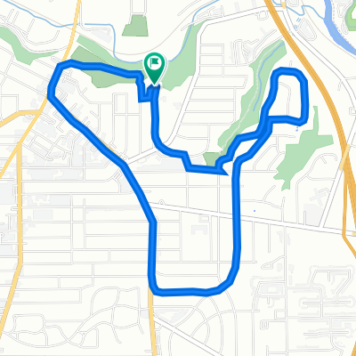
Stonebridge and Back
Cycling route in Brooklyn Heights, Ohio, United States of America
Ride down to Spring Rd- then join trail to W. 14, to Columbus, then to Stonebridge. Reture route - 25th to Pearl, then to Broadview, then home.
- 21.8 km
- Distance
- 158 m
- Ascent
- 155 m
- Descent

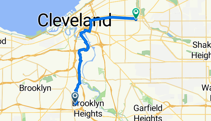
Route in Cleveland
Cycling route in Brooklyn Heights, Ohio, United States of America
- 16.1 km
- Distance
- 66 m
- Ascent
- 68 m
- Descent

3110 Saratoga Ave, Cleveland to 1400–1402 W 58th St, Cleveland
Cycling route in Brooklyn Heights, Ohio, United States of America
- 8.4 km
- Distance
- 100 m
- Ascent
- 135 m
- Descent
1703 Alvin Ave, Cleveland to 2036–2050 E 96th St, Cleveland
Cycling route in Brooklyn Heights, Ohio, United States of America
- 15.8 km
- Distance
- 82 m
- Ascent
- 112 m
- Descent
Discover more routes
 1522 Ferman Ave, Cleveland to 4407 S Hills Dr, Cleveland
- Distance
- 0.8 km
- Ascent
- 0 m
- Descent
- 0 m
- Location
- Brooklyn Heights, Ohio, United States of America
 2697 Portman Ave, Cleveland to Old Brooklyn, Cleveland
- Distance
- 5.2 km
- Ascent
- 0 m
- Descent
- 3 m
- Location
- Brooklyn Heights, Ohio, United States of America
 HOLA TACOS
- Distance
- 18.7 km
- Ascent
- 162 m
- Descent
- 183 m
- Location
- Brooklyn Heights, Ohio, United States of America
 3215 Natchez Ave, Cleveland to 2800–2806 W 11th St, Cleveland
- Distance
- 6.4 km
- Ascent
- 30 m
- Descent
- 71 m
- Location
- Brooklyn Heights, Ohio, United States of America
 1703 Alvin Ave, Cleveland to 12102 Madison Ave, Lakewood
- Distance
- 19.6 km
- Ascent
- 164 m
- Descent
- 213 m
- Location
- Brooklyn Heights, Ohio, United States of America
 4171 W 20th St, Cleveland to 4171 W 20th St, Cleveland
- Distance
- 12 km
- Ascent
- 111 m
- Descent
- 110 m
- Location
- Brooklyn Heights, Ohio, United States of America
 4171 W 20th St, Cleveland to 4175 W 20th St, Cleveland
- Distance
- 6.2 km
- Ascent
- 32 m
- Descent
- 30 m
- Location
- Brooklyn Heights, Ohio, United States of America
 2215 Oakpark Ave, Cleveland to 3883–3899 Wildlife Way, Cleveland
- Distance
- 5.5 km
- Ascent
- 35 m
- Descent
- 86 m
- Location
- Brooklyn Heights, Ohio, United States of America