
Cycling in Männedorf / Dorfkern
Discover a map of 57 cycling routes and bike trails near Männedorf / Dorfkern, created by our community.
Region portrait
Get to know Männedorf / Dorfkern
Find the right bike route for you through Männedorf / Dorfkern, where we've got 57 cycle routes to explore. Most people get on their bikes to ride here in the months of June and July.
15,449 km
Tracked distance
57
Cycle routes
4,893
Population
Community
Most active users in Männedorf / Dorfkern


From our community
The best bike routes in and around Männedorf / Dorfkern

Abendrunde Männedorf-Kempraten-Wolfhausen-Männedorf
Cycling route in Männedorf / Dorfkern, Canton of Zurich, Switzerland
- 25.8 km
- Distance
- 229 m
- Ascent
- 229 m
- Descent

Greifenseerunde
Cycling route in Männedorf / Dorfkern, Canton of Zurich, Switzerland
- 52.6 km
- Distance
- 598 m
- Ascent
- 598 m
- Descent

Pfannenstil-Abend-Route
Cycling route in Männedorf / Dorfkern, Canton of Zurich, Switzerland
- 21.5 km
- Distance
- 521 m
- Ascent
- 522 m
- Descent

Männedorf - Zuger See und zurück
Cycling route in Männedorf / Dorfkern, Canton of Zurich, Switzerland
- 105.2 km
- Distance
- 1,069 m
- Ascent
- 1,069 m
- Descent
Discover more routes
 Training
- Distance
- 91.7 km
- Ascent
- 2,108 m
- Descent
- 2,109 m
- Location
- Männedorf / Dorfkern, Canton of Zurich, Switzerland
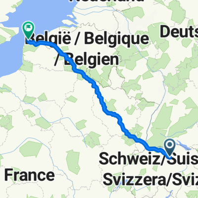 Mdorf - Calais direkt
- Distance
- 845.3 km
- Ascent
- 5,797 m
- Descent
- 6,219 m
- Location
- Männedorf / Dorfkern, Canton of Zurich, Switzerland
 Zürich - Freiburg
- Distance
- 146.6 km
- Ascent
- 1,566 m
- Descent
- 1,691 m
- Location
- Männedorf / Dorfkern, Canton of Zurich, Switzerland
 Training Horgen
- Distance
- 34.1 km
- Ascent
- 659 m
- Descent
- 240 m
- Location
- Männedorf / Dorfkern, Canton of Zurich, Switzerland
 Ausfahrt von Männedorf nach Uetikon am See
- Distance
- 27.1 km
- Ascent
- 320 m
- Descent
- 329 m
- Location
- Männedorf / Dorfkern, Canton of Zurich, Switzerland
 pfanni 1
- Distance
- 24 km
- Ascent
- 488 m
- Descent
- 494 m
- Location
- Männedorf / Dorfkern, Canton of Zurich, Switzerland
 Männedorf - Küsnacht - Aesch - Pfannenstiel
- Distance
- 33.1 km
- Ascent
- 500 m
- Descent
- 503 m
- Location
- Männedorf / Dorfkern, Canton of Zurich, Switzerland
 Glärnischstrasse 191, Männedorf nach Saurenbachstrasse 56, Männedorf
- Distance
- 31.5 km
- Ascent
- 1,139 m
- Descent
- 696 m
- Location
- Männedorf / Dorfkern, Canton of Zurich, Switzerland