 / Brühlberg")
Cycling in Stadt Winterthur (Kreis 1) / Brühlberg
Discover a map of 36 cycling routes and bike trails near Stadt Winterthur (Kreis 1) / Brühlberg, created by our community.
Region portrait
Get to know Stadt Winterthur (Kreis 1) / Brühlberg
Find the right bike route for you through Stadt Winterthur (Kreis 1) / Brühlberg, where we've got 36 cycle routes to explore. Most people get on their bikes to ride here in the month of July.
1,804 km
Tracked distance
36
Cycle routes
1,476
Population
Community
Most active users in Stadt Winterthur (Kreis 1) / Brühlberg


From our community
The best bike routes in and around Stadt Winterthur (Kreis 1) / Brühlberg

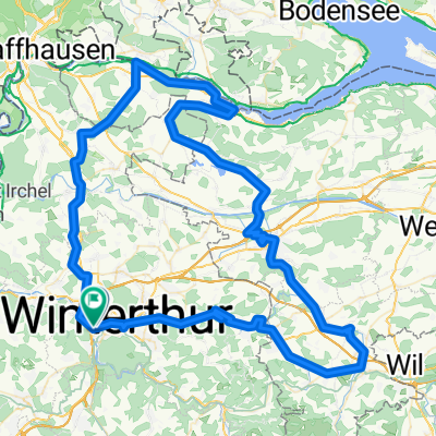
Tour de Canton
Cycling route in Stadt Winterthur (Kreis 1) / Brühlberg, Canton of Zurich, Switzerland
- 113.1 km
- Distance
- 549 m
- Ascent
- 549 m
- Descent

54km bülach wangen
Cycling route in Stadt Winterthur (Kreis 1) / Brühlberg, Canton of Zurich, Switzerland
- 54.4 km
- Distance
- 519 m
- Ascent
- 521 m
- Descent

Winty Rhein Romanshorn Camp
Cycling route in Stadt Winterthur (Kreis 1) / Brühlberg, Canton of Zurich, Switzerland
- 104.2 km
- Distance
- 1,160 m
- Ascent
- 1,123 m
- Descent

Brühlwaldrunde
Cycling route in Stadt Winterthur (Kreis 1) / Brühlberg, Canton of Zurich, Switzerland
- 5.5 km
- Distance
- 210 m
- Ascent
- 210 m
- Descent
Discover more routes
 Schlosshofstrasse 44, Winterthur nach Wangen, Öhningen
- Distance
- 38.7 km
- Ascent
- 370 m
- Descent
- 407 m
- Location
- Stadt Winterthur (Kreis 1) / Brühlberg, Canton of Zurich, Switzerland
 Brütten retour
- Distance
- 8.8 km
- Ascent
- 225 m
- Descent
- 24 m
- Location
- Stadt Winterthur (Kreis 1) / Brühlberg, Canton of Zurich, Switzerland
 Europa Tour 13 Winterthur - Grat
- Distance
- 113.6 km
- Ascent
- 2,350 m
- Descent
- 1,898 m
- Location
- Stadt Winterthur (Kreis 1) / Brühlberg, Canton of Zurich, Switzerland
 Bauma -- Winterthur
- Distance
- 47 km
- Ascent
- 654 m
- Descent
- 653 m
- Location
- Stadt Winterthur (Kreis 1) / Brühlberg, Canton of Zurich, Switzerland
 Winterthur - Hochfelden
- Distance
- 32.3 km
- Ascent
- 395 m
- Descent
- 419 m
- Location
- Stadt Winterthur (Kreis 1) / Brühlberg, Canton of Zurich, Switzerland
 Hop dä Bäse
- Distance
- 11.5 km
- Ascent
- 310 m
- Descent
- 103 m
- Location
- Stadt Winterthur (Kreis 1) / Brühlberg, Canton of Zurich, Switzerland
 Gerade Fahrt in Winterthur
- Distance
- 21.8 km
- Ascent
- 431 m
- Descent
- 438 m
- Location
- Stadt Winterthur (Kreis 1) / Brühlberg, Canton of Zurich, Switzerland
 Eulachtal-Frauenfeld-Stein-Diessenhofen-Winti
- Distance
- 114 km
- Ascent
- 993 m
- Descent
- 1,003 m
- Location
- Stadt Winterthur (Kreis 1) / Brühlberg, Canton of Zurich, Switzerland