
Cycling in Rauma
Discover a map of 170 cycling routes and bike trails near Rauma, created by our community.
Region portrait
Get to know Rauma
Find the right bike route for you through Rauma, where we've got 170 cycle routes to explore. Most people get on their bikes to ride here in the months of June and August.
7,522 km
Tracked distance
170
Cycle routes
36,550
Population
Community
Most active users in Rauma


From our community
The best bike routes in and around Rauma

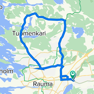
Rauma small roundtrip
Cycling route in Rauma, Satakunta Region, Finland
- 49.1 km
- Distance
- 83 m
- Ascent
- 80 m
- Descent

North East of Rauma
Cycling route in Rauma, Satakunta Region, Finland
Some minor parts of the tour are offroad in the forest. Very nice, but I did not see any elks :-)
The used roads are with very low traffic
- 68.9 km
- Distance
- 113 m
- Ascent
- 112 m
- Descent

Rauma East roundtrip 83 km
Cycling route in Rauma, Satakunta Region, Finland
A daytrip through the finnish countryside east of Rauma. The streets vary from regular mainroads (I tried to avoid those) to unpaved paths. I used a mountain bike, but the whole trip should also be possible with a regular bike.
There is only one store along the route (in Lappi - K-market, about half way point of the trip) where you can refill your water bottles or alike.
A nice scenic route, but be aware that there are quite some hills along the way.
Have fun.
- 81.2 km
- Distance
- 199 m
- Ascent
- 186 m
- Descent

Rauma Mittelstrecke
Cycling route in Rauma, Satakunta Region, Finland
Sehr gute Rennradstrecke
- 76.6 km
- Distance
- 177 m
- Ascent
- 178 m
- Descent
Discover more routes
 Snail-like route in Rauma
- Distance
- 23 km
- Ascent
- 249 m
- Descent
- 250 m
- Location
- Rauma, Satakunta Region, Finland
 Merituulentie 44, Rauma to Papinhaankatu 7, Rauma
- Distance
- 29.5 km
- Ascent
- 360 m
- Descent
- 351 m
- Location
- Rauma, Satakunta Region, Finland
 Haapasaari Roundabout
- Distance
- 18.6 km
- Ascent
- 40 m
- Descent
- 39 m
- Location
- Rauma, Satakunta Region, Finland
 Saturday Ride Rauma - Laitila v.v.
- Distance
- 71 km
- Ascent
- 156 m
- Descent
- 158 m
- Location
- Rauma, Satakunta Region, Finland
 Kiuruvahe - Pori - Route
- Distance
- 107.4 km
- Ascent
- 198 m
- Descent
- 198 m
- Location
- Rauma, Satakunta Region, Finland
 Vähämaanpuisto E, Rauma to Aittakarinkatu 20, Rauma
- Distance
- 22.2 km
- Ascent
- 170 m
- Descent
- 176 m
- Location
- Rauma, Satakunta Region, Finland
 Eurajoki Verkkokarin riippusilta - Kaaro
- Distance
- 42.6 km
- Ascent
- 71 m
- Descent
- 70 m
- Location
- Rauma, Satakunta Region, Finland
 Restful route in Monnanummi
- Distance
- 13 km
- Ascent
- 117 m
- Descent
- 124 m
- Location
- Rauma, Satakunta Region, Finland