")
Cycling in Lauffohr (Brugg)
Discover a map of 144 cycling routes and bike trails near Lauffohr (Brugg), created by our community.
Region portrait
Get to know Lauffohr (Brugg)
Find the right bike route for you through Lauffohr (Brugg), where we've got 144 cycle routes to explore. Most people get on their bikes to ride here in the months of May and June.
3,141 km
Tracked distance
144
Cycle routes
2,000
Population
Community
Most active users in Lauffohr (Brugg)


From our community
The best bike routes in and around Lauffohr (Brugg)
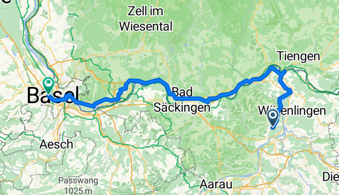
Lauffohr (Brugg) - Basel
Cycling route in Lauffohr (Brugg), Canton of Aargau, Switzerland
- 83.2 km
- Distance
- 500 m
- Ascent
- 598 m
- Descent

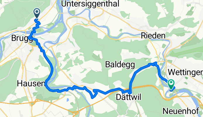
AG Stilli Sulz Klingnau Stilli
Cycling route in Lauffohr (Brugg), Canton of Aargau, Switzerland
- 49.8 km
- Distance
- 852 m
- Ascent
- 854 m
- Descent
Langmattstrasse nach Klosterstrasse
Cycling route in Lauffohr (Brugg), Canton of Aargau, Switzerland
- 16.6 km
- Distance
- 261 m
- Ascent
- 235 m
- Descent

Wiederhergestellte Route
Cycling route in Lauffohr (Brugg), Canton of Aargau, Switzerland
- 32.9 km
- Distance
- 339 m
- Ascent
- 339 m
- Descent
Discover more routes
 Ruine Besserstein- Sennhütte- Linner Wasserfall- Ruine Schenkenberg
- Distance
- 49.1 km
- Ascent
- 1,032 m
- Descent
- 1,026 m
- Location
- Lauffohr (Brugg), Canton of Aargau, Switzerland
 Ruine Besserstein- Sennhütte- Linner Wasserfall- Ruine Schenkenberg - Ruine Besserstein- Sennhütte- Linner Wasserfall- Ruine Schenkenberg
- Distance
- 48.8 km
- Ascent
- 1,190 m
- Descent
- 1,190 m
- Location
- Lauffohr (Brugg), Canton of Aargau, Switzerland
 Arbeitsweg
- Distance
- 28.9 km
- Ascent
- 203 m
- Descent
- 99 m
- Location
- Lauffohr (Brugg), Canton of Aargau, Switzerland
 Brugg - Rheinfelden
- Distance
- 50 km
- Ascent
- 344 m
- Descent
- 424 m
- Location
- Lauffohr (Brugg), Canton of Aargau, Switzerland
 Schlussetappe Siggenthal-Menziken
- Distance
- 46.2 km
- Ascent
- 461 m
- Descent
- 226 m
- Location
- Lauffohr (Brugg), Canton of Aargau, Switzerland
 Mellingen-Brugg
- Distance
- 14.5 km
- Ascent
- 93 m
- Descent
- 168 m
- Location
- Lauffohr (Brugg), Canton of Aargau, Switzerland
 lap flat
- Distance
- 26.7 km
- Ascent
- 113 m
- Descent
- 101 m
- Location
- Lauffohr (Brugg), Canton of Aargau, Switzerland
 Rüfenach - Attiswil
- Distance
- 69.6 km
- Ascent
- 237 m
- Descent
- 146 m
- Location
- Lauffohr (Brugg), Canton of Aargau, Switzerland
Routes from Lauffohr (Brugg)
By bicycle from
Lauffohr (Brugg) to Schinznach Bad
Routes to Lauffohr (Brugg)
By bicycle from
Schinznach Bad to Lauffohr (Brugg)