
Cycling in Onga
Discover a map of 48 cycling routes and bike trails near Onga, created by our community.
Region portrait
Get to know Onga
Find the right bike route for you through Onga, where we've got 48 cycle routes to explore.
10,931 km
Tracked distance
48
Cycle routes
4,697
Population
Community
Most active users in Onga


From our community
The best bike routes in and around Onga


Onga - Búza tér - Tricikli Bt.
Cycling route in Onga, Borsod-Abauj Zemplen county, Hungary
- 9.6 km
- Distance
- 164 m
- Ascent
- 112 m
- Descent

Onga-Halmaj-Hernádkércs temető körút
Cycling route in Onga, Borsod-Abauj Zemplen county, Hungary
- 27.4 km
- Distance
- 48 m
- Ascent
- 36 m
- Descent

Onga - Lillafüred
Cycling route in Onga, Borsod-Abauj Zemplen county, Hungary
- 27 km
- Distance
- 217 m
- Ascent
- 13 m
- Descent
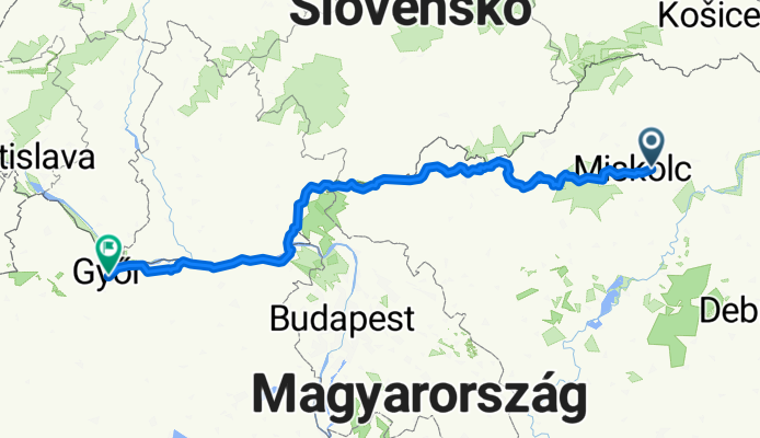
Onga - Győr
Cycling route in Onga, Borsod-Abauj Zemplen county, Hungary
- 338.3 km
- Distance
- 1,193 m
- Ascent
- 1,187 m
- Descent
Discover more routes
 Burger King MC
- Distance
- 7.3 km
- Ascent
- 121 m
- Descent
- 122 m
- Location
- Onga, Borsod-Abauj Zemplen county, Hungary
 Munkába menet (go to work)
- Distance
- 9.5 km
- Ascent
- 24 m
- Descent
- 18 m
- Location
- Onga, Borsod-Abauj Zemplen county, Hungary
 Dózsa György utca 2, Onga to Névtelen út, Győr
- Distance
- 378.5 km
- Ascent
- 3,306 m
- Descent
- 3,304 m
- Location
- Onga, Borsod-Abauj Zemplen county, Hungary
 Onga - Paris
- Distance
- 1,768.3 km
- Ascent
- 1,003 m
- Descent
- 1,077 m
- Location
- Onga, Borsod-Abauj Zemplen county, Hungary
 Onga (HUN) - Igló (SK) gyors/fastest
- Distance
- 143.9 km
- Ascent
- 2,060 m
- Descent
- 1,708 m
- Location
- Onga, Borsod-Abauj Zemplen county, Hungary
 Onga - Józsi bácsi fagyizója - Alsózsolca
- Distance
- 9.4 km
- Ascent
- 31 m
- Descent
- 31 m
- Location
- Onga, Borsod-Abauj Zemplen county, Hungary
 Onga to Aggtelek
- Distance
- 60.8 km
- Ascent
- 552 m
- Descent
- 324 m
- Location
- Onga, Borsod-Abauj Zemplen county, Hungary
 onga hernádkércs túra
- Distance
- 25.8 km
- Ascent
- 64 m
- Descent
- 13 m
- Location
- Onga, Borsod-Abauj Zemplen county, Hungary